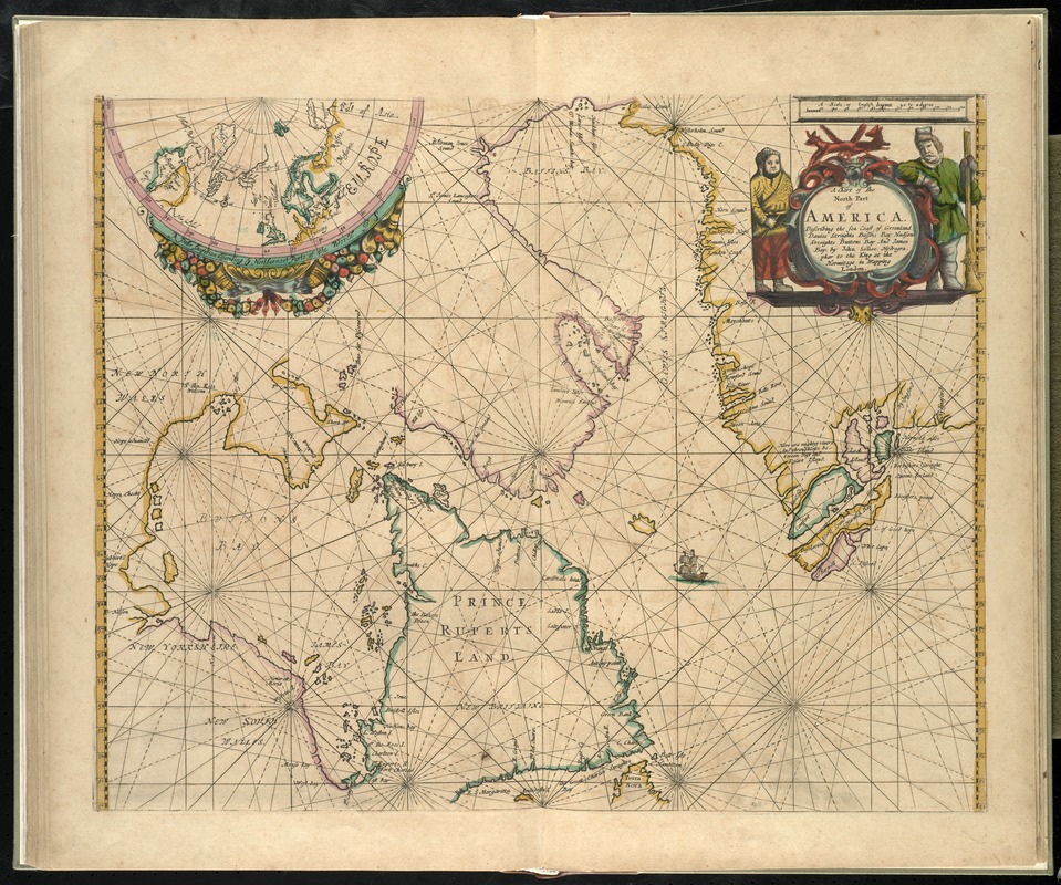
A Chart of the north part of America, describing the sea coast of Groenland, Dawies Streights, Baffins Bay, Hudsons Streights, Buttons Bay and James Bay
Item Information
- Title:
- A Chart of the north part of America, describing the sea coast of Groenland, Dawies Streights, Baffins Bay, Hudsons Streights, Buttons Bay and James Bay
- Creator:
- Seller, John, fl. 1658-1698
- Name on Item:
-
by John Seller.
- Date:
-
[1672?]
- Format:
-
Maps/Atlases
- Location:
-
Boston Public Library
Norman B. Leventhal Map Center - Collection (local):
-
Norman B. Leventhal Map Center Collection
- Subjects:
-
Atlantic Coast (Canada)--Maps--Early works to 1800
Newfoundland and Labrador--Maps--Early works to 1800
Québec (Province)--Maps--Early works to 1800
- Places:
-
CanadaNewfoundland and Labrador (province)
- Extent:
- 1 map : hand col. ; 44 x 52 cm.
- Terms of Use:
-
No known copyright restrictions.
No known restrictions on use.
- Publisher:
-
London :
John Seller
- Scale:
-
Scale [ca. 1: 7 400 000]
- Language:
-
English
- Notes:
-
Map of eastern Canada, including Newfoundland and Labrador, Quebec, and the western coast of Greenland.
Inset: A polar projection describing ye northermost parts of the world.
Appears in the author's Atlas maritimus, or A book of charts. London : John Seller, [1672?]
Cataloging, conservation, and digitization made possible in part by The National Endowment for the Humanities: Exploring the human endeavor.
Atlas scanned by Internet Archive http://archive.org/details/atlasmaritimusor00sell
- Identifier:
-
06_01_007936
- Call #:
-
G1059 .S45 1672
- Barcode:
-
30000003777730