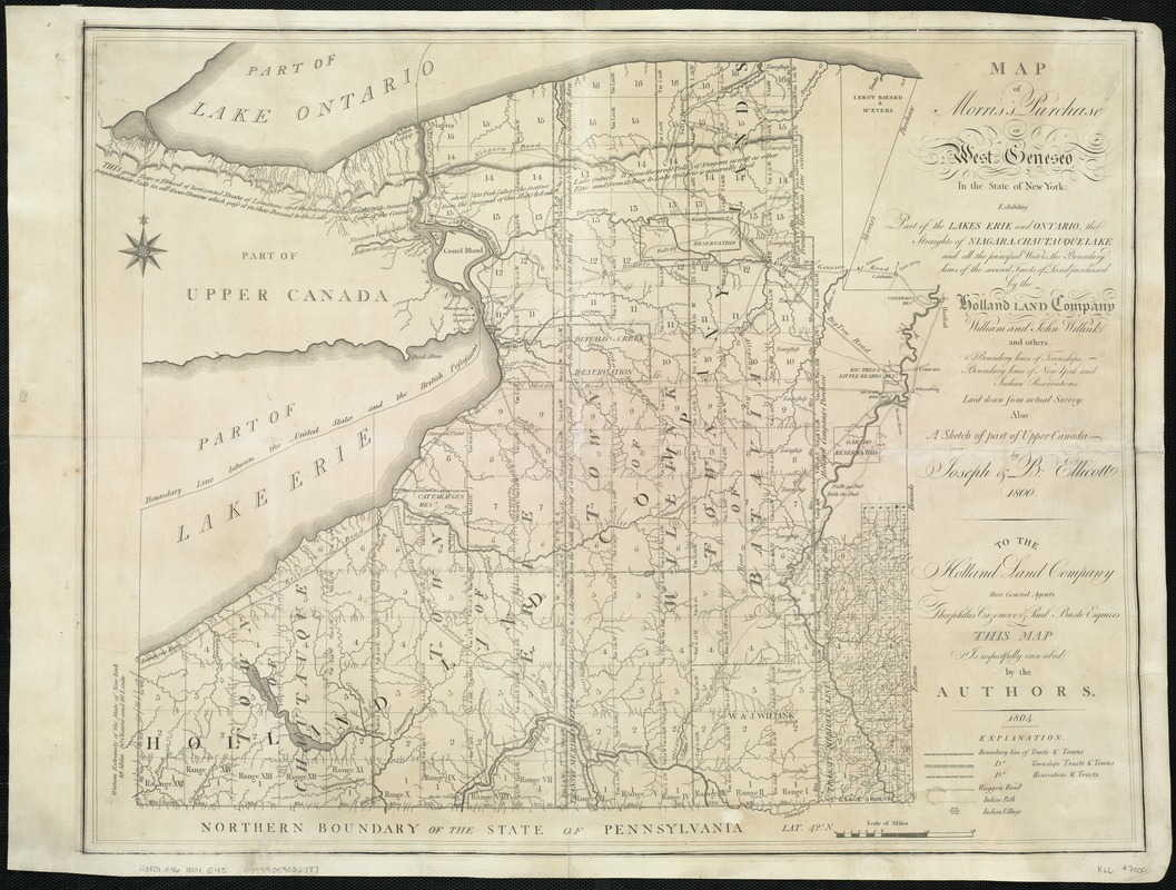
Map of Morris's Purchase or West Geneseo in the state of New York : exhibiting part of the Lakes Erie and Ontario, the Straights of Niagara, Chautauque Lake, and all the principal waters, the boundary lines of the several tracts of land purchased by the Holland Land Company, William and John Willink, and others, boundary lines of townships, boundary lines of New York and Indian reservations, laid down from actual survey, also a sketch of part of Upper Canada
Item Information
- Title:
- Map of Morris's Purchase or West Geneseo in the state of New York : exhibiting part of the Lakes Erie and Ontario, the Straights of Niagara, Chautauque Lake, and all the principal waters, the boundary lines of the several tracts of land purchased by the Holland Land Company, William and John Willink, and others, boundary lines of townships, boundary lines of New York and Indian reservations, laid down from actual survey, also a sketch of part of Upper Canada
- Description:
-
This map demonstrates the process by which Americans expanded westward and took over Native American territories. Based on surveys by brothers Joseph and Benjamin Ellicott, the map promotes the Holland Land Company’s real estate interests in western New York, a territory previously occupied by the Seneca Indians and claimed by Massachusetts. The extensive pattern of squares delineates townships available for land sales and eventual American settlement. The smaller irregular tracts identify lands reserved for Native Americans. The Senecas relinquished their rights to these lands, except for the reservations, in a treaty negotiated in 1797.
- Creator:
- Ellicott, Joseph, 1760-1826
- Name on Item:
-
by Joseph & B. Ellicott, 1800.
- Date:
-
1804
- Format:
-
Maps/Atlases
- Location:
-
Boston Public Library
Norman B. Leventhal Map Center - Collection (local):
-
Norman B. Leventhal Map Center Collection
- Subjects:
-
Real property--New York (State)--Maps
Indian reservations--New York (State)--Maps
New York (State)--Maps
1800
- Places:
-
New York
- Extent:
- 1 map ; 51 x 65 cm.
- Terms of Use:
-
No known copyright restrictions.
No known restrictions on use.
- Publisher:
-
New York? :
[Holland Land Co.?]
- Edition:
- 2nd state.
- Scale:
-
Scale [ca. 1:336,000].
- Language:
-
English
- Notes:
-
Shows Indian Reservations.
Covers far western New York State.
Includes statement of dedication dated 1804.
This map can be viewed as a georeferenced overlay in an interactive application made especially for We Are One: Mapping America's Road from Revolution to Independence http://d2o8owo4k087al.cloudfront.net/index.html?mapId=93.
- Notes (exhibitions):
-
Exhibited: "We Are One: Mapping America's Road from Revolution to Independence" organized by the Norman B. Leventhal Map Center at the Boston Public Library, 2015.
- Identifier:
-
06_01_007522
- Call #:
-
G3801.G46 1804 .E45
- Barcode:
-
39999059032787


