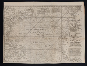
Terra nova, ac maris tractus circa Novam Franciam, Angliam, Belgium, Venezuelam Novam, Andalusiam, Guianan, et Brasiliam = Terra neuf, en de custen van Nieu Vranckryck, Nieu Engeland, Nieu Nederland, Nieu Andalusia, Guiana en Venezuela
Item Information
- Title:
- Terra nova, ac maris tractus circa Novam Franciam, Angliam, Belgium, Venezuelam Novam, Andalusiam, Guianan, et Brasiliam = Terra neuf, en de custen van Nieu Vranckryck, Nieu Engeland, Nieu Nederland, Nieu Andalusia, Guiana en Venezuela
- Title (alt.):
-
Terra neuf, en de custen van Nieu Vranckryck, Nieu Engeland, Nieu Nederland, Nieu Andalusia, Guiana en Venezuela
- Creator:
- Wit, Frederik de.
- Name on Item:
-
F. de Wit.
- Date:
-
[1680]
- Format:
-
Maps/Atlases
- Location:
-
Boston Public Library
Norman B. Leventhal Map Center - Collection (local):
-
Norman B. Leventhal Map Center Collection
- Subjects:
-
Nautical charts--North Atlantic Ocean--Early works to 1800
North Atlantic Ocean--Maps--Early works to 1800
- Places:
-
Atlantic Ocean
- Extent:
- 1 map : col. ; 48 x 57 cm.
- Terms of Use:
-
No known copyright restrictions.
No known restrictions on use.
- Publisher:
-
Amsterdam :
Gedruckt by Fredrick de Wit in de Kalverstraet
- Scale:
-
Scale [ca. 1:12,521,000].
- Language:
-
Latin
- Notes:
-
Shows the Atlantic Ocean west of the Azores and Cape Verde Islands, and the coasts of northeastern North America and northern South Amerca.
Oriented with north to the left.
Includes two decorative cartouches and ill.
"22" in upper right margin.
In Latin and Dutch.
- Notes (date):
-
This date is inferred.
- Identifier:
-
06_01_007227
- Call #:
-
G9110 1680 .W57x
- Barcode:
-
39999059030237