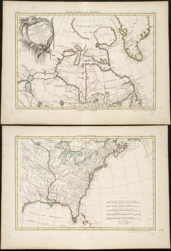
Partie de l'Amerique Septentrionale, qui comprend le Canada, la Louisiane, le Labrador, le Groenland, la Nouvelle Angleterre, la Floride, &c
This map is also available in American Revolutionary Geographies Online (ARGO), a collections portal especially built for material relating to the American Revolutionary War Era. Visit ARGO to learn more about this item and explore the historical geography of North America in the late eighteenth century.
Item Information
- Title:
- Partie de l'Amerique Septentrionale, qui comprend le Canada, la Louisiane, le Labrador, le Groenland, la Nouvelle Angleterre, la Floride, &c
- Creator:
- Bonne, Rigobert, 1727-1794
- Name on Item:
-
par Mr. Bonne.
- Date:
-
1776
- Format:
-
Maps/Atlases
- Location:
-
Boston Public Library
Norman B. Leventhal Map Center - Collection (local):
-
Norman B. Leventhal Map Center Collection
- Subjects:
-
North America--Maps--Early works to 1800
United States--History--Revolution, 1775-1783--Maps--Early works to 1800
- Places:
-
North America (area)
- Extent:
- 1 map on 2 sheets : col. ; 66 x 42 cm, sheets 38 x 52 cm.
- Terms of Use:
-
No known copyright restrictions.
No known restrictions on use.
- Publisher:
-
A Paris :
Chez Lattré
- Scale:
-
Scale ca. 1:10,600,000.
- Language:
-
French
- Notes:
-
Relief shown pictorially.
At top margin of top sheet "XXXIV. Theatre de la Guerre en Amerique. A32." At bottom margin of top sheet: "Canada Ire. feuille."
At top margin of bottom sheet: XXXV. Canada IIe Feuille. B32."
Cataloging, conservation, and digitization made possible in part by The National Endowment for the Humanities: Exploring the human endeavor.
- Identifier:
-
06_01_006155
- Call #:
-
G3300 1776 .B66
- Barcode:
-
39999059020782


