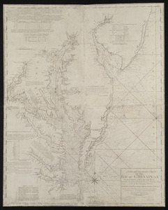
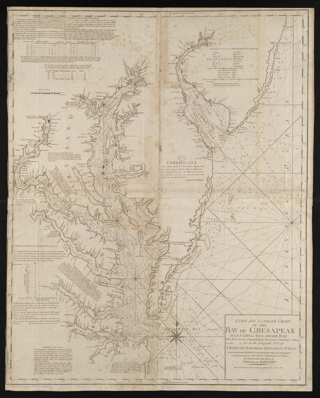
A new and accurate chart of the Bay of Chesapeak including Delaware Bay with all the shoals, channels, islands, entrances, soundings, & sailing marks as far as the navigable part of the rivers Patowmack Patapsco & N. East
This map is also available in American Revolutionary Geographies Online (ARGO), a collections portal especially built for material relating to the American Revolutionary War Era. Visit ARGO to learn more about this item and explore the historical geography of North America in the late eighteenth century.
Item Information
- Title:
- A new and accurate chart of the Bay of Chesapeak including Delaware Bay with all the shoals, channels, islands, entrances, soundings, & sailing marks as far as the navigable part of the rivers Patowmack Patapsco & N. East
- Creator:
- Smith, Anthony, pilot of St. Marys
- Cartographer:
- Smith, Anthony, pilot of St. Marys
- Publisher:
- Norman, John, 1748?-1817
- Name on Item:
-
drawn from several draughts made by the most experienced navigators chiefly from those of Anthony Smith pilot of St. Mapys and compared with the latest surveys of Virginia and Maryland
- Date:
-
[1794]
- Format:
-
Maps/Atlases
- Location:
-
Boston Public Library
Norman B. Leventhal Map Center - Collection (local):
-
Norman B. Leventhal Map Center Collection
- Subjects:
-
Coasts--Delaware--Early works to 1800
Coasts--Maryland--Early works to 1800
Coasts--New Jersey--Early works to 1800
Coasts--Virginia--Early works to 1800
Nautical charts--Delaware Bay (Del. and N.J.)--Early works to 1800
Nautical charts--Chesapeake Bay (Md. and Va.)--Early works to 1800
Delaware Bay (Del. and N.J.)--Maps--Early works to 1800
Chesapeake Bay (Md. and Va.)--Maps--Early works to 1800
- Places:
-
Delaware Bay
Chesapeake Bay
- Extent:
- 1 map ; 93 x 81 cm
- Terms of Use:
-
No known copyright restrictions.
No known restrictions on use.
- Publisher:
-
[Boston] :
John Norman
- Scale:
-
Scale approximately 1:351,000
- Language:
-
English
- Notes:
-
Depths shown by soundings.
Includes notes, tables and certificate.
In John Norman's American pilot. Boston : John Norman, 1794.
- Notes (date):
-
This date is inferred.
- Identifier:
-
06_01_004804
- Call #:
-
G1106.P5 N6 1794x
- Barcode:
-
30000005058360