Plan of Boston
Item Information
- Title:
- Plan of Boston
- Description:
-
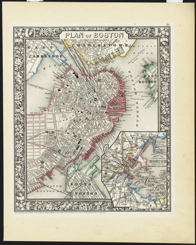
Boston's role as a transportation center during the mid-19th century is evident on this general reference atlas map. Wharves lining the eastern shore of the peninsula provide evidence of the city's long-time shipping industry. Meanwhile, there were eight train stations located within the city proper, indicating the growing importance of rail traffic to the city's growth. In addition, the regional inset shows these rail lines radiating out to the neighboring suburbs and industrial towns in eastern Massachusetts.
- Creator:
- Mitchell, S. Augustus (Samuel Augustus), 1792-1868
- Date:
-
1860
- Format:
-
Maps/Atlases
- Location:
- Private Collection
- Collection (local):
-
Mapping Boston Collection
- Subjects:
-
Boston (Mass.)--Maps
Boston Harbor (Mass.)--Maps
- Places:
-
Boston Harbor
- Extent:
- 1 map : hand col. ; 25 x 20 cm., on sheet 39 x 31 cm.
- Terms of Use:
-
No known copyright restrictions.
This work is licensed for use under a Creative Commons Attribution Non-Commercial Share Alike License (CC BY-NC-SA).

- Publisher:
-
Philadelphia :
[S.A. Mitchell, Jr.]
- Scale:
-
Scale [ca. 1:16,900]
- Language:
-
English
- Notes:
-
Ancillary map: Map of the country around Boston showing also its harbor & islands.
"20" in upper right corner.
"Entered according to Act of Congress in the year 1860 by S. Augustus Mitchell, Jr. in the Clerks Office of the District Court of the U.S. for the Eastern District of Pennsylvania."
- Identifier:
-
06_01_001150
- Barcode:
-
39999052508114


