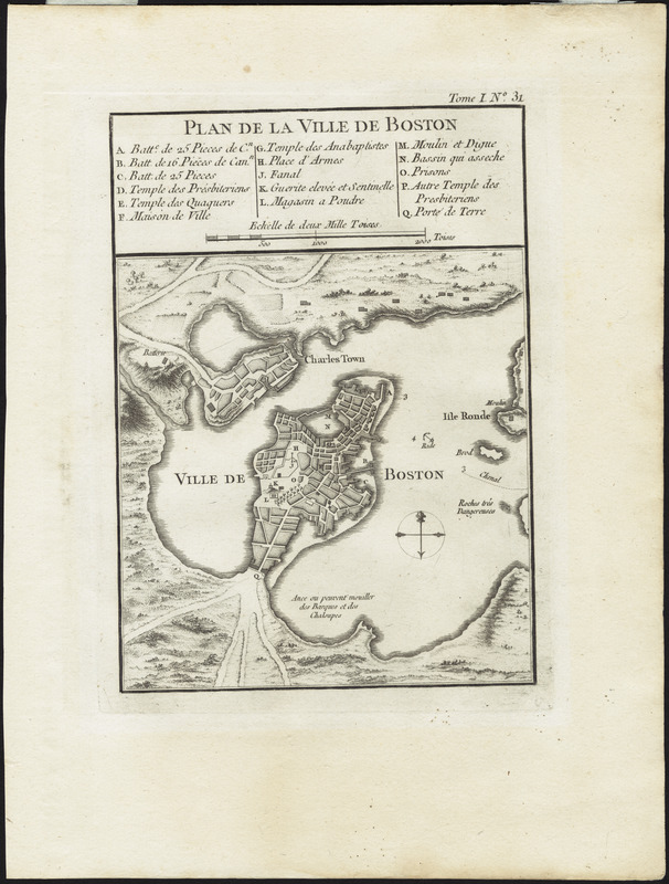
Plan de la ville de Boston
This map is also available in American Revolutionary Geographies Online (ARGO), a collections portal especially built for material relating to the American Revolutionary War Era. Visit ARGO to learn more about this item and explore the historical geography of North America in the late eighteenth century.
Item Information
- Title:
- Plan de la ville de Boston
- Description:
-
Published for a French audience, this small, page-sized map depicts Boston and Charlestown. The legend identifies fortifications, churches, and other public buildings. Although unsigned, this plan is similar to others prepared by Bellin, hydrographer to the French King.
- Cartographer:
- Bellin, Jacques Nicolas, 1703-1772
- Date:
-
[1764]
- Format:
-
Maps/Atlases
- Location:
- Private Collection
- Collection (local):
-
Mapping Boston Collection
- Subjects:
-
Boston (Mass.)--Maps--Early works to 1800
- Places:
-
Suffolk (county)Boston
- Extent:
- 1 map : hand col. ; 30 x 23 cm.
- Terms of Use:
-
No known copyright restrictions.
This work is licensed for use under a Creative Commons Attribution Non-Commercial Share Alike License (CC BY-NC-SA).

- Publisher:
-
[Paris] :
[Bellin]
- Scale:
-
Scale ca. 1:130,000
- Language:
-
French
- Notes:
-
Relief shown pictorially.
Includes index to points of interest.
Appears in Bellin's Petite atlas maritime. Paris, 1764.
In upper margin: "Tome I. No. 31."
- Notes (date):
-
This date is inferred.
- Identifier:
-
06_01_001177
- Barcode:
-
30000001744567


