Squeezing out the competition
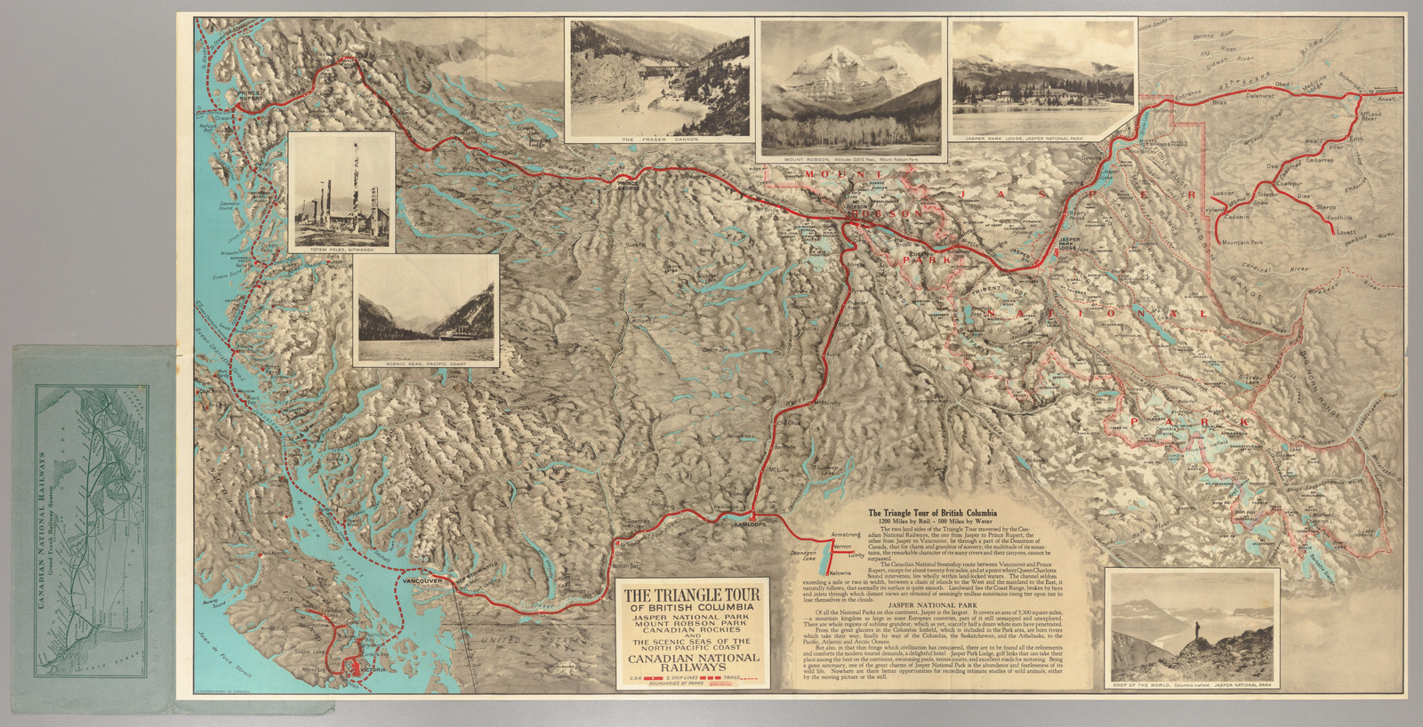
| Title | The Triangle Tour of British Columbia. Jasper National Park. Mount Robson Park. Canadian Rockies. And the Scenic Seas of the North Pacific Coast. |
| Creator | Canadian National Railways |
| Year | 1927 |
| Dimensions | 43 × 76 cm |
| Location | P.J. Mode Collection, Cornell University Library |
At first glance, this map of the Canadian National Railways’ route into the Rockies, illustrated with hillshading and adorned with picturesque photographs, seems like an ordinary tourist guide. It's only when comparing it to the real geography of western Canada that its deceptive choices about scale and distance become apparent. Here's how this map would have to be distorted to fit on a Mercator projection, with a reference map layered beneath as a comparison:
This warped view shows how the eastern (right) side of the map has to be puckered up like a deflated balloon in order to match the more realistically proportioned map beneath it. That means the original map has dramatically swollen that same area out, creating an effect where the map is projected with two different scales in the left and right sections. There are no visual clues, however, like scale bars or break points, to warn the reader that this distortion is taking place. Instead, the map does everything it can to make this funhouse-mirror version of western Canada seem natural and normal.
Why would the Canadian National Railways want to play so fast and loose with projection and scale? As with the Boston, Concord, Montreal, and White Mountains Railroad, stretching out an area in which a railroad line has many stations is a useful technique for emphasizing an area for a reader's attention. But the Canadian National also gained another advantage from blowing up the Canadian Rockies in this particular way. By zooming in on Jasper Lodge and the section of the Rockies from Mount Robson to Bow Lake, this map completely erases the southern section of Banff National Park, where the main line of Canadian National's major rival, the Canadian Pacific, brought travelers to the competing resort at Lake Louise. ()
The transcontinental railroads across Canada and the United States were originally built to haul passengers and freight from one side of the mountains to the other, as we explore in our exhibition America Transformed. But the railroad companies soon sensed a lucrative new source of profits in well-heeled tourists who wanted to stop along the way, spending time in the “wilderness” and seeking a respite from dirty industrial cities. The railroads sank money into building tourist amenities like grand lodges and promoted the scenic splendor of the mountains with maps and photographs. () In this way, railroad advertisements helped to construct the appealing images of outdoor recreation, embedding their own routes and destinations into the geography of the picturesque. Destinations like Jasper loomed figuratively large in the tourist imagination in much the same way as this map exploded the region to make it spatially large.
Bibliography
- Cronin 2011
- J. Keri Cronin, Manufacturing National Park Nature: Photography, Ecology, and the Wilderness Industry of Jasper (Vancouver: UBC Press, 2011). oclc:856788118
- Cornell 2017
- P. J. Mode, Katherine Reagan, et al., Persuasive Cartography: The PJ Mode Collection, Cornell University Library, Division of Rare & Manuscript Collections (2017). https://persuasivemaps.library.cornell.edu