A new exhibition at the Leventhal Map & Education Center explores an extraordinary moment in the urban transformation of Boston through the lens of the Center’s urban atlas collection.
In-person show opens January 13 in the Leventhal Center gallery at the Boston Public Library with accompanying digital exhibition available soon.
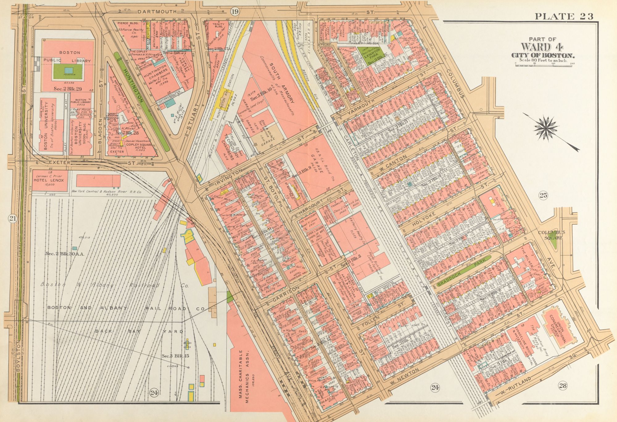
A 1938 atlas plate of Back Bay offers a detailed snapshot of the neighborhood’s bustling businesses, residences, and transport.
BOSTON — December 9, 2022 — A new exhibition that brings to the life the street-scale changes of Boston a century ago opens January 13 at the Leventhal Map & Education Center (LMEC) at the Boston Public Library (BPL). Building Blocks: Boston Stories from Urban Atlases features rare materials from the BPL’s historic collection of maps and atlases alongside lithographs, photographs, and sketches of familiar local landscapes. Visitors will discover how the atlas collections opens up a world of fascinating stories, with vignettes including the city’s first African Meeting House in the heart of Beacon Hill, landmarks of leisure like the “Derby Racer” and “Giant Safety Thriller” amusement rides in Revere, public health infrastructure on Gallops Island in Boston Harbor, and many more.
Building Blocks is open from January 13 through August 19, 2023 and, like all exhibitions at the Leventhal Center, it is free to the public at the Central Library in Copley Square.
“The world got a bit bigger and more connected at the turn of the twentieth century, and not unlike our own time, the cityscape reflected tremendous social transformations. I think we need to see multiple layers to keep pace with all the change,” says Exhibition Curatorial Fellow Laura Lee Schmidt. “The urban atlases shown in this exhibition act like a flip book for urban metamorphosis—we can look through successive views of the same parcel of land over time. Building Blocks aims to explore the potentials for telling stories of a dynamic period. It’s surprising what can come to life in maps.”
Among the exhibition highlights:
- A building-by-building look at the transforming city skyline, featuring Boston’s first skyscraper at 1 Court Street and the rising height of the Custom House Tower in Boston’s Financial District. [Image 1; Image 2]
- A collection of local histories uncovered and reconstructed by a team of teen curators from Boston Public Schools, including the origins of Ronan Park in Dorchester, Kelleher Rose Garden in Back Bay Fens, and the once-bustling cattle industry of Brighton. [Image 1; Image 2; Image 3]
- An interwoven, biographic account of Florida Ruffin Ridley, a young, Black Bostonian teacher, activist and writer who worked, studied, played, and created within the landscapes on display. [Image]
Beyond the stories narrated in this exhibition, the rich details of the atlases hint at thousands, or even millions, of others. Because the Leventhal Center’s atlas collection includes fine-grained detail down to the individual shapes of buildings and owners of property, Building Blocks invites visitors to discover their own stories in the maps.
A Digital Exhibition with the Power of Atlascope
For those who can’t visit the in-person exhibition at the Boston Public Library, an extensive companion digital exhibition will feature the collections and interpretive stories from the exhibition in a rich interactive format. The online exhibition will feature a self-guided tour of the themes and objects in the live show, links to related essays and resources, zoomable views of ultra-high-resolution historic objects, and lesson plans and classroom items for teachers.
Building Blocks utilizes the same collection of atlases that are accessible in the Leventhal Center’s widely-used digital tool Atlascope™, available for free public use at atlascope.leventhalmap.org. Atlascope offers the ability to overlay more than 100 urban atlases directly over a modern web map, and makes it easy to flip through layers of historical change from a desktop or mobile device. With the opening of Building Blocks in the Leventhal Center’s exhibition gallery, the Center will also release a new, upgraded version of the Atlascope tool, with new features to empower storytelling, annotation, and discovery, as well as connections into other Massachusetts digital collections. Atlascope and the Building Blocks digital exhibition together form a suite of digital tools that will make Boston one of the extraordinary sites in the United States to conduct fine-scale historical map investigations in a manner that is widely accessible to both specialists and non-specialists alike.
“The Leventhal Center is a leader in developing digital tools that put geography and history together in fascinating new ways,” says Garrett Dash Nelson, President & Head Curator. “Building Blocks opens the question of what we might see in the history of familiar spaces when we look carefully at these detailed urban atlases. Atlascope then empowers citizens to go answer those questions for themselves.”
Education and Public Access
Building Blocks will feature a variety of ways for young people, educators, and families to explore everyday life in Boston a century ago. Window nooks geared to young people will feature activities such as a matching game identifying the shapes of locations in the atlases (such as the vanished South End baseball grounds) with photos of those same places. “Young people visiting the exhibition, especially K-12 students with their classes or families, can connect to the history of Florida Ruffin Ridley and trace her story as a Black Bostonian teacher, activist and writer at the turn of the twentieth-century,” says Michelle LeBlanc, Director of Education. “The atlases and locations featured in this exhibition are great ways to talk with young people about their communities have changed over time, both the built environment and the people who live there.”
Community Events
Public events and outreach programs during the run of Building Blocks will include curatorial talks, local history deep dives, and hands-on workshops, both at the Central Library, online, and in other in-person venues. More details on exhibition-related activities will be announced later this spring at leventhalmap.org/event.
Hours and Exhibition Details
Building Blocks: Boston Stories from Urban Atlases is open Tuesdays, Thursdays, Fridays, and Saturdays from 11 am-5 pm, Wednesdays from 1-7 pm, and Sundays from 1-5pm. Admission is free. Guided tours are available at all times by request.
- More information on the exhibition, including directions, access and visitor requirements can be found at leventhalmap.org/exhibitions.
- An updated calendar of events and programs associated with Building Blocks can be found at leventhalmap.org/event.
Funding Information
This project is sponsored in part by the Library of Congress Teaching with Primary Sources Eastern Region Program, coordinated by Waynesburg University.
The original development of Atlascope™ was funded in part by the Council for Library and Information Resources (CLIR) and the Associates of the Boston Public Library.
Media Contact
To arrange interviews about Building Blocks, curator-guided visits to the Leventhal Map and Education Center, or for digital images of exhibition objects, contact the Leventhal Center’s Public Engagement Coordinator Megan Nally, mnally@leventhalmap.org / 617-859-2383.
About the Leventhal Map & Education Center
The Norman B. Leventhal Map & Education Center at the Boston Public Library is an independent nonprofit organization that promotes the public use of more than a quarter million geographic objects for the enjoyment and education of all. Uniquely positioned in a public library, the Leventhal Center offers exhibitions and public talks, groundbreaking educational programs that promote geographic and data literacy, and extensive digital resources.
The Leventhal Center is known for the size and significance of its collection, as well as its engagement with K-12 audiences. With a global scope and a regional specialization in Boston and New England, the Center is a leader in exploring the study of places, societies, landscapes and history through the lens of maps and geography.
About the Boston Public Library
Established in 1848, the Boston Public Library is a pioneer of public library service in America. It was the first large, free municipal library in the United States; the first public library to lend books; the first to have a branch library; and the first to have a children’s room.
The Boston Public Library of today is a robust system that includes the Central Library in Copley Square, 25 neighborhood branches, the Norman B. Leventhal Map and Education Center, the Kirstein Business and Innovation Center, and an archival center, offering public access to world-class special collections of rare books, manuscripts, photographs, and prints, along with rich digital content and online services.
The Boston Public Library serves nearly 4 million visitors per year and millions more online. All of its programs and exhibitions are free to all and open to the public.
The Boston Public Library is a department of the City of Boston, under the leadership of Mayor Michelle Wu. To learn more, visit bpl.org.