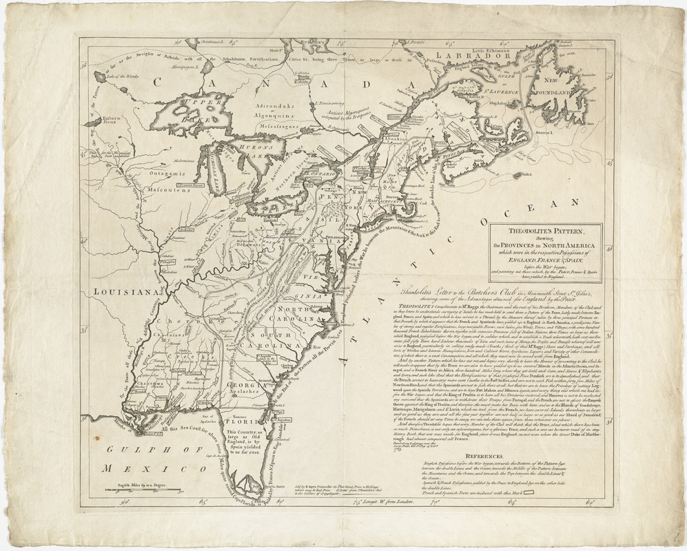
Theodolite's pattern, shewing the provinces in North America which were in the respective possessions of England, France & Spain, before the war began : and pointing out those which, by the peace, France & Spain have yielded to England
This map is also available in American Revolutionary Geographies Online (ARGO), a collections portal especially built for material relating to the American Revolutionary War Era. Visit ARGO to learn more about this item and explore the historical geography of North America in the late eighteenth century.
Item Information
- Title:
- Theodolite's pattern, shewing the provinces in North America which were in the respective possessions of England, France & Spain, before the war began : and pointing out those which, by the peace, France & Spain have yielded to England
- Description:
-
Shows territorial possessions in North America after the Treaty of Paris. Includes the satirical "Theodolite's letter to the Botcher's Club in Monmouth Street." The open letter appears to praise the treaty and the 3rd Earl of Bute, who worked on the treaty, while actually pointing out the weaknesses of the territory gained. Theodolite, a scientific instrument used in surveying, likely represented Bute, who collected such instruments. Botchers were menders such as tailor and cobblers, and Monmouth Street was known for its second-hand shops. The letter was thus from Bute to those with mercantile interests or low connections as Bute?s peers disapproved of him and the treaty. The true author of the letter was likely Sayer or a colleague with similar political sentiments.
- Creator:
- Sayer, Robert, 1725-1794
- Date:
-
1763
- Format:
-
Maps/Atlases
- Location:
- George Washington's Mount Vernon
- Collection (local):
-
Richard H. Brown Revolutionary War Map Collection at Mount Vernon
- Subjects:
-
Indians of North America--Maps--Early works to 1800
Political satire
Great Britain--Territories and possessions--Maps--Early works to 1800
North America--Maps--Early works to 1800
United States--History--French and Indian War, 1754-1763--Maps--Early works to 1800
- Places:
-
North America (area)
- Extent:
- 1 map ; 42 x 47 cm
- Terms of Use:
-
No known copyright restrictions.
This work is licensed for use under a Creative Commons Attribution Non-Commercial Share Alike License (CC BY-NC-SA).

- Publisher:
-
[London] :
R. Sayer
- Scale:
-
Scale approximately 1:7,200,000
- Language:
-
English
- Catalog Record:
-
MVLA record
- Notes:
-
Shows possessions, towns, forts and Indian territories.
Relief shown pictorially.
Includes "Theodolite's letter to the Botcher's Club in Monmouth Street St. Giles's, shewing some of the advantages obtained for England by the peace".
- Identifier:
-
06_01_014553


![Copy of a map presented to the Congres [sic]](https://bpldcassets.blob.core.windows.net/derivatives/images/commonwealth:z603vn16x/image_thumbnail_300.jpg)

