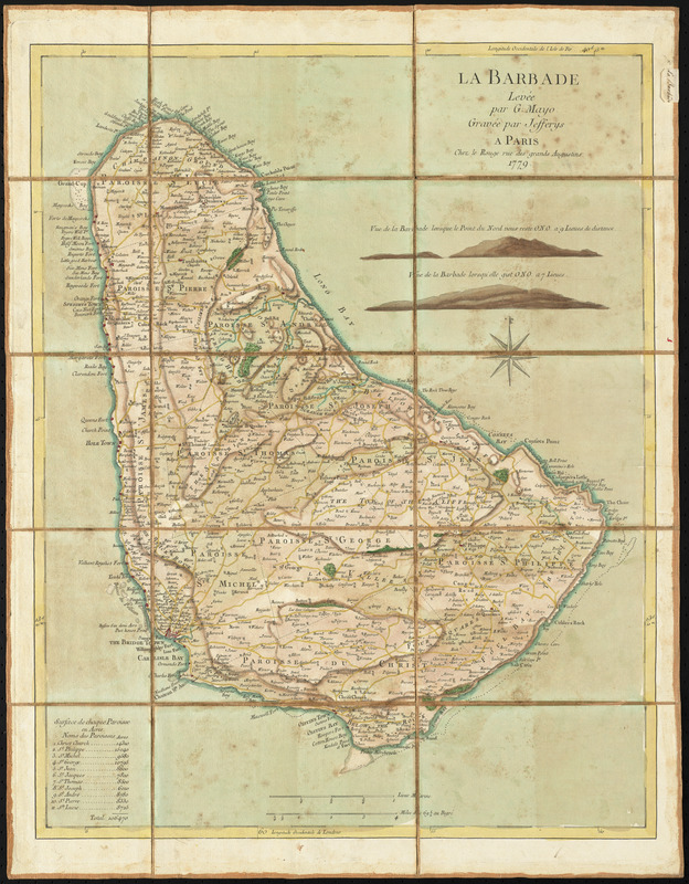
La Barbade
This map is also available in American Revolutionary Geographies Online (ARGO), a collections portal especially built for material relating to the American Revolutionary War Era. Visit ARGO to learn more about this item and explore the historical geography of North America in the late eighteenth century.
Item Information
- Title:
- La Barbade
- Creator:
- Le Rouge, Georges-Louis
- Contributor:
- Jefferys, Thomas, -1771
- Contributor:
- Mayo, William, (Surveyor)
- Name on Item:
-
levée par G. Mayo ; gravée par Jefferys
- Date:
-
1779
- Format:
-
Maps/Atlases
- Location:
- George Washington's Mount Vernon
- Collection (local):
-
Richard H. Brown Revolutionary War Map Collection at Mount Vernon
- Subjects:
-
Parishes--Barbados--Maps--Early works to 1800
Barbados--Maps--Early works to 1800
- Places:
-
Barbados
- Extent:
- 1 map : hand color ; 59 x 46 cm.
- Terms of Use:
-
No known copyright restrictions.
This work is licensed for use under a Creative Commons Attribution Non-Commercial Share Alike License (CC BY-NC-SA).

- Publisher:
-
Paris :
Le Rouge
- Scale:
-
Scale [ca. 1:47,000]
- Language:
-
French
- Catalog Record:
-
MVLA record
- Notes:
-
Shows parishes, towns, bays, anchorages, topography and shoals
Relief shown by hachures.
Prime meridians: London and Ferro.
Includes 2 views: Vue de la Barbade lorsque le Point du Nord vous reste O.N.O. a 9 lieues de distance -- Vue de la Barbade lorsqu'elle gist O.N.O. a 7 lieues.
Includes list of acreage of parishes.
Manuscript label on verso: No. 57. Isle de la Barbade.
From the Library of the Ducs de Luynes from the Château de Dampierre.
- Notes (citation):
-
LC Maps of North America, 1750-1789, 2093
- Identifier:
-
06_01_010487
- Barcode:
-
30000003568426