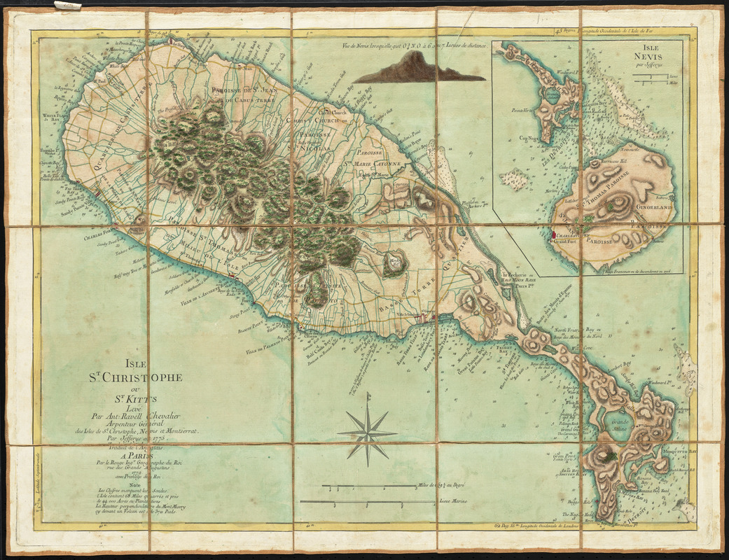
Isle St. Christophe ou St. Kitts
This map is also available in American Revolutionary Geographies Online (ARGO), a collections portal especially built for material relating to the American Revolutionary War Era. Visit ARGO to learn more about this item and explore the historical geography of North America in the late eighteenth century.
Item Information
- Title:
- Isle St. Christophe ou St. Kitts
- Creator:
- Le Rouge, Georges-Louis
- Contributor:
- Ravell, Anthony
- Contributor:
- Jefferys, Thomas, -1771
- Name on Item:
-
levé par Ant. Ravell Chevalier Arpenteur Général des Isles de St. Christophe, Nevis et Montserrat ; par Jefferys en 1775 ; traduit de l'Anglais [par le Rouge]
- Date:
-
1779
- Format:
-
Maps/Atlases
- Location:
- George Washington's Mount Vernon
- Collection (local):
-
Richard H. Brown Revolutionary War Map Collection at Mount Vernon
- Subjects:
-
Parishes--Saint Kitts--Maps--Early works to 1800
Saint Kitts and Nevis--Maps--Early works to 1800
- Places:
-
Saint Kitts (island)
- Extent:
- 1 map : hand color ; 46 x 61 cm.
- Terms of Use:
-
No known copyright restrictions.
This work is licensed for use under a Creative Commons Attribution Non-Commercial Share Alike License (CC BY-NC-SA).

- Publisher:
-
Paris :
Le Rouge
- Scale:
-
Scale [ca. 1:55,200]
- Language:
-
French
- Catalog Record:
-
MVLA record
- Notes:
-
Shows parishes, settlements, bays, anchorages, topography and shoals.
Relief shown by hachures. Depths shown by soundings.
Prime meridians: Ferro and London.
Inset: Isle Nevis par Jefferys.
Includes "Vue de Nevis lorsqu'elle gist O 1/4 N.O. à 6 ou 7 lieues de distance."
Manuscript label on verso: No. 52. Isle St. Cristophe double.
From the Library of the Ducs de Luynes from the Château de Dampierre.
- Notes (citation):
-
LC Maps of North America, 1750-1789, 1990
- Identifier:
-
06_01_010491
- Barcode:
-
30000003567946


![[A map of part of Pennsylvania & Maryland intended to shew, at one view, the several places proposed for opening a communication between the waters of the Delaware & Chesopeak Bays]](https://bpldcassets.blob.core.windows.net/derivatives/images/commonwealth:z603vt12v/image_thumbnail_300.jpg)


