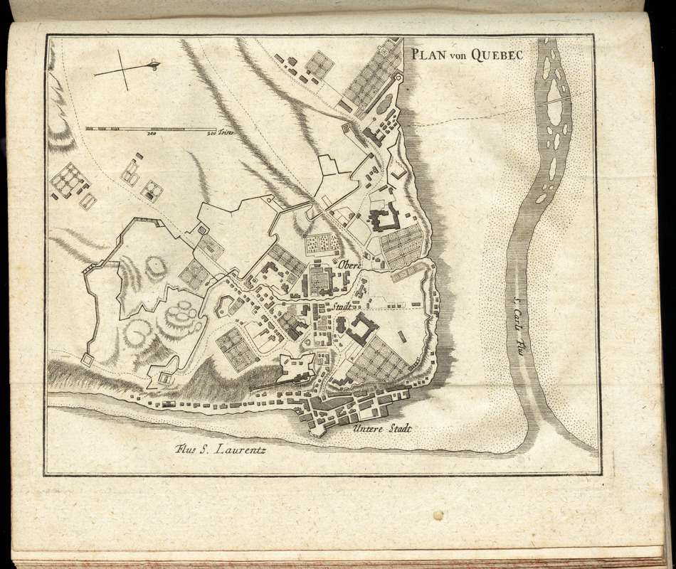
Plan von Quebec
This map is also available in American Revolutionary Geographies Online (ARGO), a collections portal especially built for material relating to the American Revolutionary War Era. Visit ARGO to learn more about this item and explore the historical geography of North America in the late eighteenth century.
Item Information
- Title:
- Plan von Quebec
- Creator:
- Korn, Christoph Heinrich, 1726-1783
- Publisher:
- Raspe, Gabriel Nicolaus, 1712-1785
- Date:
-
[1777]
- Format:
-
Maps/Atlases
- Location:
- George Washington's Mount Vernon
- Collection (local):
-
Richard H. Brown Revolutionary War Map Collection at Mount Vernon
- Subjects:
-
Canada--History--Revolution, 1775-1783--Maps--Early works to 1800
Québec (Québec)--Maps--Early works to 1800
- Places:
-
CanadaQuébec
- Extent:
- 1 map ; 14 x 17 cm.
- Terms of Use:
-
No known copyright restrictions.
This work is licensed for use under a Creative Commons Attribution Non-Commercial Share Alike License (CC BY-NC-SA).

- Publisher:
-
Nuremberg :
Gabriel Nicolaus Raspe
- Scale:
-
Scale [ca. 1:9,600]
- Language:
-
German
- Catalog Record:
-
MVLA record
- Notes:
-
Oriented with north towards the upper right.
Relief shown by hachures.
In the author's Geschichte der kriege in und ausser Europa, dritter theil (Nurnberg : Gabriel Nicolaus Raspe, 1777).
- Notes (date):
-
This date is inferred.
- Identifier:
-
06_01_010208