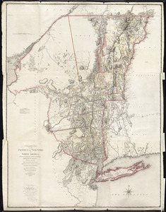
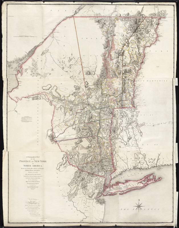
A chorographical map of the Province of New-York in North America, divided into counties, manors, patents and townships : exhibiting likewise all the private grants of land made and located in that Province
This map is also available in American Revolutionary Geographies Online (ARGO), a collections portal especially built for material relating to the American Revolutionary War Era. Visit ARGO to learn more about this item and explore the historical geography of North America in the late eighteenth century.
Item Information
- Title:
- A chorographical map of the Province of New-York in North America, divided into counties, manors, patents and townships : exhibiting likewise all the private grants of land made and located in that Province
- Description:
-
French-born surveyor Claude Joseph Sauthier produced many manuscript maps of New York and Staten Island during the early years of the Revolution. He compiled this map between 1771 and 1774 under the direction of the Governor of New York. The map was eventually engraved and published in London by William Faden five years later in 1779. Sauthier's finely detailed maps includes natural features and topography, boundaries, roads and establishments such as houses, taverns and forts.
- Creator:
- Sauthier, Claude Joseph
- Publisher:
- Faden, William, 1749-1836
- Name on Item:
-
compiled from actual surveys deposited in the Patent Office at New York, by order of His Excellency Major General William Tryon, by Claude Joseph Sauthier ; engraved and published by William Faden.
- Date:
-
1779
- Format:
-
Maps/Atlases
- Location:
- George Washington's Mount Vernon
- Collection (local):
-
Richard H. Brown Revolutionary War Map Collection at Mount Vernon
- Subjects:
-
Real property--New York (State)--Maps--Early works to 1800
New York (State)--Maps--Early works to 1800
New York (State)--Administrative and political divisions--Maps--Early works to 1800
- Places:
-
New York
- Extent:
- 1 map on 3 sheets : col. ; 186 x 138 cm, sheets 62 x 41 cm.
- Terms of Use:
-
No known copyright restrictions.
This work is licensed for use under a Creative Commons Attribution Non-Commercial Share Alike License (CC BY-NC-SA).

- Publisher:
-
London :
Wm. Faden
- Scale:
-
Scale [ca. 1:326,000]
- Language:
-
English
- Catalog Record:
-
MVLA record
- Notes:
-
Relief shown by hachures. Depths shown by form lines.
Hand colored.
Prime meridian: London.
Inscribed: To His Excellency Major General William Tryon ...
"Advertisement. The tracts of land coloured red, are military grants ... Those with a green edge are manors, and those coloured yellow are townships ... "
Appears in Thomas Jefferys' The American atlas. 1776.
Cataloging, conservation, and digitization made possible in part by The National Endowment for the Humanities: Exploring the human endeavor.
- Identifier:
-
06_01_009623
- LCCN:
-
74692647