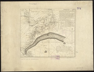
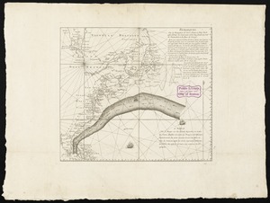
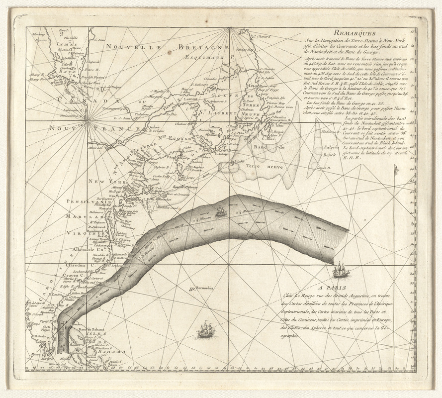
Remarques sur la navigation de terre-neuve à New-York afin d'eviter les courrants et les bas-fonds au sud de Nantuckett et du Banc de George
This map is also available in American Revolutionary Geographies Online (ARGO), a collections portal especially built for material relating to the American Revolutionary War Era. Visit ARGO to learn more about this item and explore the historical geography of North America in the late eighteenth century.
Item Information
- Title:
- Remarques sur la navigation de terre-neuve à New-York afin d'eviter les courrants et les bas-fonds au sud de Nantuckett et du Banc de George
- Description:
-
One of the preferred routes that captains and navigators sailing from America to England learned to use was the Gulf Stream, a strong, warm current that flows north along the Atlantic coast and then east toward Europe. Initially charted by Benjamin Franklin in 1768, this discovery helped ships minimize travel time across the ocean, speeding up the transatlantic voyage for travelers, merchants, and goods. Franklin purchased this 1785 chart, a French adaptation of his original findings, when he served in Paris as a diplomat for the United States during the early years of the republic.
- Creator:
- Le Rouge, Georges-Louis
- Contributor:
- Folger, Timothy
- Contributor:
- Franklin, Benjamin, 1706-1790
- Date:
-
[1785]
- Format:
-
Maps/Atlases
- Location:
- George Washington's Mount Vernon
- Collection (local):
-
Richard H. Brown Revolutionary War Map Collection at Mount Vernon
- Subjects:
-
Gulf Stream--Maps
- Places:
-
Atlantic Ocean
- Extent:
- 1 map ; 32 x 36 cm. on sheet 47 x 62 cm.
- Terms of Use:
-
No known copyright restrictions.
This work is licensed for use under a Creative Commons Attribution Non-Commercial Share Alike License (CC BY-NC-SA).

- Publisher:
-
A Paris :
Chéz Le Rouge, rue des Grands Augustins ...
- Scale:
-
Scale [ca. 1:10,500,000]
- Language:
-
French
- Catalog Record:
-
MVLA record
- Notes:
-
Based on Timothy Folger's original annotations ... It would appear that [Benjamin] Franklin added little or nothing beyond the red lines which indicated the portion to be reproduced ...--De Vorsey, L. Pioneer charting of the Gulf Stream, in Imago mundi, 28 (1976), p. 107.
- Notes (date):
-
This date is inferred.
- Identifier:
-
06_01_009556

![[Chart of the Gulf Stream]](https://bpldcassets.blob.core.windows.net/derivatives/images/commonwealth:z603vr47j/image_thumbnail_300.jpg)