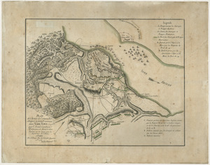
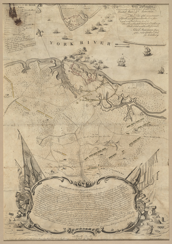
To His Excellency Genl. Washington, Commander in Chief of the armies of the United States of America : this plan of the investment of York and Gloucester has been surveyed and laid down
This map is also available in American Revolutionary Geographies Online (ARGO), a collections portal especially built for material relating to the American Revolutionary War Era. Visit ARGO to learn more about this item and explore the historical geography of North America in the late eighteenth century.
Item Information
- Title:
- To His Excellency Genl. Washington, Commander in Chief of the armies of the United States of America : this plan of the investment of York and Gloucester has been surveyed and laid down
- Title (alt.):
-
Plan of the investment of York and Gloucester
- Description:
-
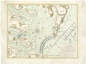
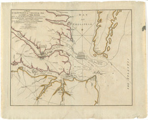
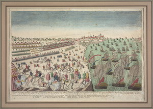
Sebastian Bauman, a topographical engineer who immigrated to North America from Germany, created this map shortly after the British surrender at Yorktown. Dedicated to George Washington, it was the first American-published map of the battle. The plan depicts the British troops (colored red), who were waiting for new supplies and reinforcements, surrounded by the French and American troops (colored yellow and blue). Bauman used pictorial symbols to represent the French navy’s victory over the British in the York River. The lower portion contains a description of the battle embellished with instruments of war and the American flag, one of its earliest representations on a published map.
- Creator:
- Bauman, Sebastian
- Contributor:
- Scot, Robert, 1745-1823
- Name on Item:
-
and is most humbly dedicated by His Excellency's obedient and very humble servant, Sebastn. Bauman, Major of the New York or 2nd Regt. of Artillery ; R. Scot, sculp.
- Date:
-
1782
- Format:
-
Maps/Atlases
- Location:
- George Washington's Mount Vernon
- Collection (local):
-
Richard H. Brown Revolutionary War Map Collection at Mount Vernon
- Subjects:
-
Gloucester (Va.)--Maps--Early works to 1800
Yorktown (Va.)--History--Siege, 1781--Maps--Early works to 1800
Yorktown (Va.)--History--18th century--Maps--Early works to 1800
- Places:
-
VirginiaGloucester (county)Gloucester
VirginiaYork (county)Yorktown
- Extent:
- 1 map : hand col. ; 66 x 48 cm.
- Terms of Use:
-
No known copyright restrictions.
This work is licensed for use under a Creative Commons Attribution Non-Commercial Share Alike License (CC BY-NC-SA).

- Publisher:
-
Philad :
[s.n.]
- Scale:
-
Scale [ca. 1:14,500]
- Language:
-
English
- Catalog Record:
-
MVLA record
- Notes:
-
Shows units, ships, lines of fire, and successive positions.
Oriented with north to the upper left.
Relief shown by hachures.
"This plan was taken between the 22nd & 28th of October, 1781."
Includes "References to the British lines" with illus. of ships and "Explanation" of the American and French siege operations.
This map can be viewed as a georeferenced overlay in an interactive application made especially for We Are One: Mapping America's Road from Revolution to Independence http://d2o8owo4k087al.cloudfront.net/index.html?mapId=80.
- Notes (exhibitions):
-
Exhibited: "We Are One: Mapping America's Road from Revolution to Independence" organized by the Norman B. Leventhal Map Center at the Boston Public Library, 2015.
- Identifier:
-
06_01_009565