A map of the United States of N. America
This map is also available in American Revolutionary Geographies Online (ARGO), a collections portal especially built for material relating to the American Revolutionary War Era. Visit ARGO to learn more about this item and explore the historical geography of North America in the late eighteenth century.
Item Information
- Title:
- A map of the United States of N. America
- Description:
-
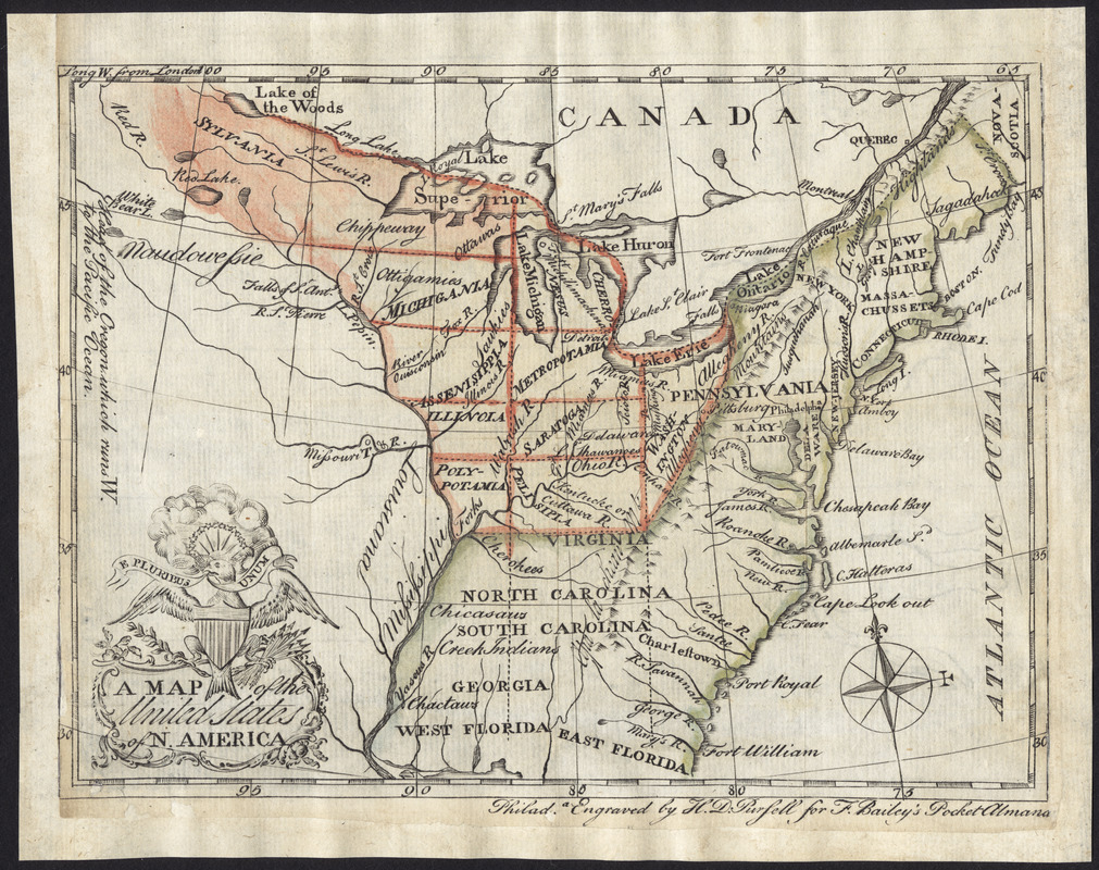
The map displayed here was produced after the American Revolutionary war, when settlement of the Old Northwest was popular. To create an orderly and diplomatic process with the native inhabitants of the region, the Continental Congress imposed the Land Ordinance of 1784. This legislation regulated the governance of the territory, and divided the region into ten states, each with specified boundaries. Thomas Jefferson proposed ten names for the states, which are included on this map and outlined in light red. The Great Seal of the United States also appears in the ornamental cartouche.
- Creator:
- Pursell, Henry D.
- Publisher:
- Bailey, Francis, 1735?-1815
- Name on Item:
-
engraved by H.D. Pursell for F. Bailey's pocket almanac.
- Date:
-
[1784]
- Format:
-
Maps/Atlases
- Location:
- George Washington's Mount Vernon
- Collection (local):
-
Richard H. Brown Revolutionary War Map Collection at Mount Vernon
- Subjects:
-
United States--Maps--Early works to 1800
- Places:
-
- Extent:
- 1 map : hand col. ; 13 x 17 cm.
- Terms of Use:
-
No known copyright restrictions.
This work is licensed for use under a Creative Commons Attribution Non-Commercial Share Alike License (CC BY-NC-SA).

- Publisher:
-
Philad[elphi]a :
[Francis Bailey
- Scale:
-
Scale [ca. 1:17,500,000]
- Language:
-
English
- Notes:
-
The first known published map to show Jefferson's proposed state names in the Old Northwest.
Relief shown pictorially.
From: Bailey's pocket atlas, 1785.
This map can be viewed as a georeferenced overlay in an interactive application made especially for We Are One: Mapping America's Road from Revolution to Independence http://d2o8owo4k087al.cloudfront.net/index.html?mapId=90.
- Notes (date):
-
This date is inferred.
- Notes (exhibitions):
-
Exhibited: "We Are One: Mapping America's Road from Revolution to Independence" organized by the Norman B. Leventhal Map Center at the Boston Public Library, 2015.
- Identifier:
-
06_01_008538


