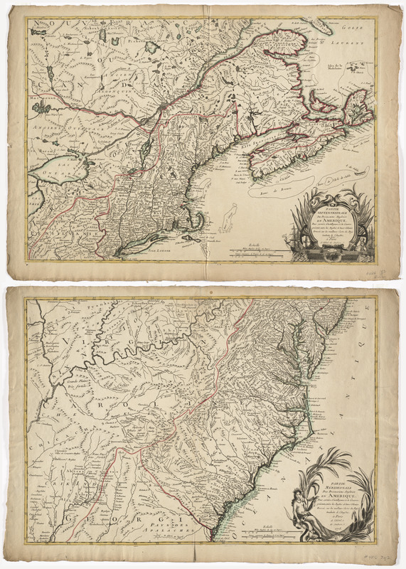
Partie septentrionale des possessions angloise en Amérique : pour servire d'intelligence à la guerre présente entre les Anglois et leurs colonies dressée sur les meilleurs carte du pays
This map is also available in American Revolutionary Geographies Online (ARGO), a collections portal especially built for material relating to the American Revolutionary War Era. Visit ARGO to learn more about this item and explore the historical geography of North America in the late eighteenth century.
Item Information
- Title:
- Partie septentrionale des possessions angloise en Amérique : pour servire d'intelligence à la guerre présente entre les Anglois et leurs colonies dressée sur les meilleurs carte du pays
- Title (alt.):
-
Partie méridionale des possessions angloise en Amerique
- Description:
-
This pair of French maps illustrates the seat of war in America during the Revolution. Published at a time when French cartographers relied upon English maps for new information, Ambrose Perrier and Francois Verrier engraved these maps using John Mitchell's A Map of the British and French Dominions. Perrier and Verrier ordered copies of of English publisher Williams Faden's recent stock to produce their own North American maps for a French audience. Each sheet displayed here has its own title and decorative cartouche, however, when viewed together the maps tell a more complete story of the war
- Creator:
- Mitchell, John, 1711-1768
- Contributor:
- Hôtel de Soubise (Paris, France)
- Name on Item:
-
traduite de l'anglois, de Michel à Paris a l'Hôtel de Soubise ; Partie méridionale des possessions angloise en Amérique : pour servire d'intelligence à la guerre présente, entre les Anglois et leurs colonies, dressée sur les meilleurs cartes du pays / traduite de l'anglois à Paris a l'Hôtel de Soubise.
- Date:
-
1778
- Format:
-
Maps/Atlases
- Location:
- George Washington's Mount Vernon
- Collection (local):
-
Richard H. Brown Revolutionary War Map Collection at Mount Vernon
- Subjects:
-
United States--Maps--Early works to 1800
- Places:
-
- Extent:
- 2 maps : hand col. ; map 104 x 146 cm., on sheets 51 x 72 cm.
- Terms of Use:
-
No known copyright restrictions.
This work is licensed for use under a Creative Commons Attribution Non-Commercial Share Alike License (CC BY-NC-SA).

- Publisher:
-
Paris :
Hôtel de Soubise
- Scale:
-
Scale [ca. 1:2,100,000]
- Language:
-
English
French
- Catalog Record:
-
MVLA record
- Notes:
-
Relief shown pictorially.
Based on John Mitchell's map of North America.
In French.
- Identifier:
-
06_01_008529


