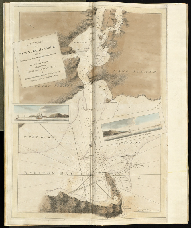
A chart of New York Harbour with the soundings views of land marks and nautical directions : for the use of pilotage
This map is also available in American Revolutionary Geographies Online (ARGO), a collections portal especially built for material relating to the American Revolutionary War Era. Visit ARGO to learn more about this item and explore the historical geography of North America in the late eighteenth century.
Item Information
- Title:
- A chart of New York Harbour with the soundings views of land marks and nautical directions : for the use of pilotage
- Creator:
- Des Barres, Joseph F. W. (Frederick Wallet), 1722-1824
- Contributor:
- Knight, John
- Contributor:
- Hunter, John, 1737-1821
- Name on Item:
-
composed from surveys and observations of lieutenants John Knight, John Hunter of the Navy & others.
- Date:
-
1777
- Format:
-
Maps/Atlases
- Location:
- George Washington's Mount Vernon
- Collection (local):
-
Richard H. Brown Revolutionary War Map Collection at Mount Vernon
- Subjects:
-
Nautical charts--New York Harbor (N.Y. and N.J.)--Early works to 1800
Harbors--New York (State)--New York Region--Maps--Early works to 1800
Nautical charts--New York (State)--New York Region--Early works to 1800
New York Harbor (N.Y. and N.J.)--Maps--Early works to 1800
- Places:
-
New York
- Extent:
- 1 map : hand col. ; 80 x 56 cm.
- Terms of Use:
-
No known copyright restrictions.
This work is licensed for use under a Creative Commons Attribution Non-Commercial Share Alike License (CC BY-NC-SA).

- Publisher:
-
[London] :
Publish'd by J.F.W. Des Barres Esqr.
- Scale:
-
Scale [ca. 1:52,000]
- Language:
-
English
- Catalog Record:
-
MVLA record
- Notes:
-
2nd state.
Relief shown by hachures and shading. Depths shown by soundings.
Appears in Des Barres's Atlantic Neptune.
Inset views: Bond Hollow bearing s. b[y] e. -- Mount Pleasant half way between the cedars on the Hook & the light house.
- Identifier:
-
06_01_010109