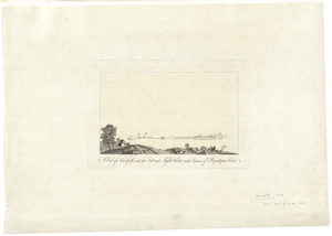
[View of Portsmouth, N.H.]
![[View of Portsmouth, N.H.]](https://bpldcassets.blob.core.windows.net/derivatives/images/commonwealth:dz010v19c/image_access_800.jpg)
This map is also available in American Revolutionary Geographies Online (ARGO), a collections portal especially built for material relating to the American Revolutionary War Era. Visit ARGO to learn more about this item and explore the historical geography of North America in the late eighteenth century.
Item Information
- Title:
- [View of Portsmouth, N.H.]
- Creator:
- Des Barres, Joseph F. W. (Joseph Frederick Wallet), 1722-1824
- Date:
-
[1780?]
- Format:
-
Prints
- Genre:
-
Views
- Location:
- George Washington's Mount Vernon
- Collection (local):
-
Richard H. Brown Revolutionary War Map Collection at Mount Vernon
- Subjects:
-
New Hampshire--History--Revolution, 1775-1783--Pictorial works--Early works to 1800
Portsmouth (N.H.)--Pictorial works--Early works to 1800
- Places:
-
Rockingham (county)Portsmouth
- Extent:
- 1 view ; 42 x 57 cm.
- Terms of Use:
-
No known copyright restrictions.
This work is licensed for use under a Creative Commons Attribution Non-Commercial Share Alike License (CC BY-NC-SA).

- Publisher:
-
[London] :
J.F.W. Des Barres
- Scale:
-
Not drawn to scale
- Language:
-
English
- Catalog Record:
-
MVLA record
- Notes:
-
Title from published bibliography.
Depicts two figures standing on the banks of the river in the foreground; the figure on the left is pointing with his left arm.
From the author's Atlantic Neptune.
- Identifier:
-
06_01_009530


![[A map of part of Pennsylvania & Maryland intended to shew, at one view, the several places proposed for opening a communication between the waters of the Delaware & Chesopeak Bays]](https://bpldcassets.blob.core.windows.net/derivatives/images/commonwealth:z603vt12v/image_thumbnail_300.jpg)

