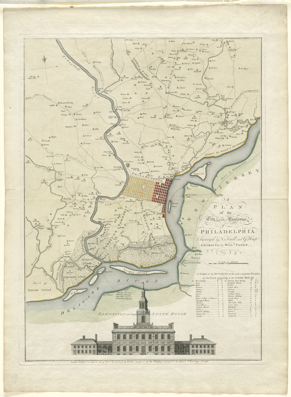
A plan of the city and environs of Philadelphia
This map is also available in American Revolutionary Geographies Online (ARGO), a collections portal especially built for material relating to the American Revolutionary War Era. Visit ARGO to learn more about this item and explore the historical geography of North America in the late eighteenth century.
Item Information
- Title:
- A plan of the city and environs of Philadelphia
- Creator:
- Scull, Nicholas, 1686?-1761?
- Author:
- Heap, George, fl. 1715-1760
- Publisher:
- Faden, William, 1749-1836
- Name on Item:
-
survey'd by N. Scull and G. Heap ; engraved by Willm. Faden
- Date:
-
1777
- Format:
-
Maps/Atlases
- Location:
- George Washington's Mount Vernon
- Collection (local):
-
Richard H. Brown Revolutionary War Map Collection at Mount Vernon
- Subjects:
-
Philadelphia (Pa.)--Maps--Early works to 1800
- Places:
-
Philadelphia (county)Philadelphia
- Extent:
- 1 map : hand col. ; 62 x 45 cm.
- Terms of Use:
-
No known copyright restrictions.
This work is licensed for use under a Creative Commons Attribution Non-Commercial Share Alike License (CC BY-NC-SA).

- Publisher:
-
London :
W. Faden
- Scale:
-
Scale [ca. 1:43,000]
- Language:
-
English
- Catalog Record:
-
MVLA record
- Notes:
-
Shows roads and the names of landholders in rural areas.
Includes "table of the distances of the most remarkable places on this plan beginning at the court house" and illustration of "elevation of the state house."
First state of the map, with an unnamed island.
- Notes (citation):
-
Comparative cartography [Stevens & Tree], 69a
LC Maps of North America, 1750-1789, 1319
- Identifier:
-
06_01_008204
- Barcode:
-
30000003793148


![[Environs of Philadelphia]](https://bpldcassets.blob.core.windows.net/derivatives/images/commonwealth:7h149x76d/image_thumbnail_300.jpg)
