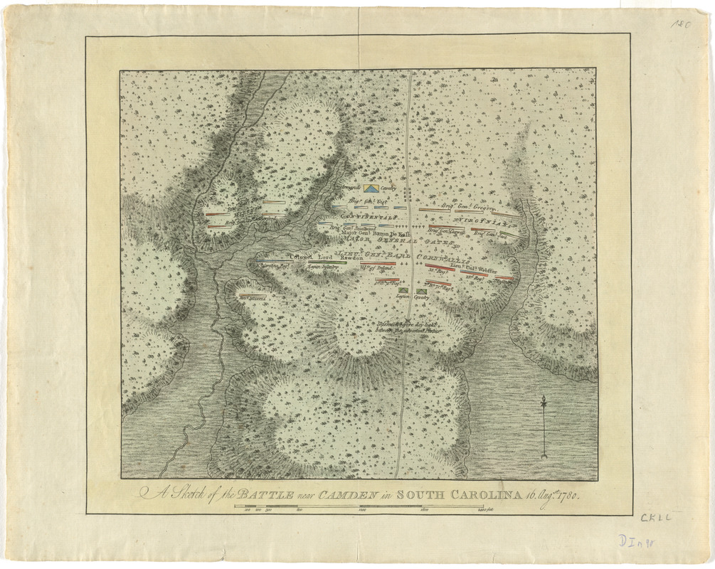
A sketch of the battle near Camden in South Carolina, 16 Augst. 1780
This map is also available in American Revolutionary Geographies Online (ARGO), a collections portal especially built for material relating to the American Revolutionary War Era. Visit ARGO to learn more about this item and explore the historical geography of North America in the late eighteenth century.
Item Information
- Title:
- A sketch of the battle near Camden in South Carolina, 16 Augst. 1780
- Title (alt.):
-
Atlantic Neptune
- Creator:
- Des Barres, Joseph F. W. (Joseph Frederick Wallet), 1722-1824
- Date:
-
[1780?]
- Format:
-
Maps/Atlases
- Location:
- George Washington's Mount Vernon
- Collection (local):
-
Richard H. Brown Revolutionary War Map Collection at Mount Vernon
- Subjects:
-
Camden, Battle of, Camden, S.C., 1780--Maps--Early works to 1800
Camden (S.C.)--History--18th century--Maps--Early works to 1800
- Places:
-
Kershaw (county)Camden
- Extent:
- 1 map : hand col. ; 25 x 29 cm.
- Terms of Use:
-
No known copyright restrictions.
This work is licensed for use under a Creative Commons Attribution Non-Commercial Share Alike License (CC BY-NC-SA).

- Publisher:
-
London? :
[s.n.]
- Scale:
-
Scale [ca. 1:5,000]
- Language:
-
English
- Catalog Record:
-
MVLA record
- Notes:
-
Relief shown by shading.
From his Atlantic Neptune.
Commanders and British regiments named.
- Identifier:
-
06_01_008232

![[A map of part of Pennsylvania & Maryland intended to shew, at one view, the several places proposed for opening a communication between the waters of the Delaware & Chesopeak Bays]](https://bpldcassets.blob.core.windows.net/derivatives/images/commonwealth:z603vt12v/image_thumbnail_300.jpg)


