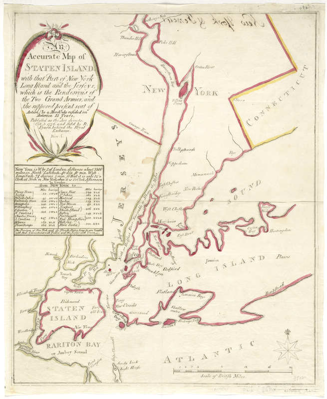
An accurate map of Staten Island : with that part of New York, Long Island and the Jerseys, which is the rendesvous of the two grand armies, and the supposed present seat of action
This map is also available in American Revolutionary Geographies Online (ARGO), a collections portal especially built for material relating to the American Revolutionary War Era. Visit ARGO to learn more about this item and explore the historical geography of North America in the late eighteenth century.
Item Information
- Title:
- An accurate map of Staten Island : with that part of New York, Long Island and the Jerseys, which is the rendesvous of the two grand armies, and the supposed present seat of action
- Contributor:
- Eynon, R.
- Name on Item:
-
by a mercht who resided in America 15 years.
- Date:
-
1776
- Format:
-
Maps/Atlases
- Location:
- George Washington's Mount Vernon
- Collection (local):
-
Richard H. Brown Revolutionary War Map Collection at Mount Vernon
- Subjects:
-
Staten Island (New York, N.Y.)--Maps--Early works to 1800
New York (N.Y.)--Maps--Early works to 1800
Long Island (N.Y.)--Maps--Early works to 1800
New Jersey--Maps--Early works to 1800
- Places:
-
New Jersey
Richmond (county)Staten Island (island)
- Extent:
- 1 map : hand col. ; 39 x 32 cm.
- Terms of Use:
-
No known copyright restrictions.
This work is licensed for use under a Creative Commons Attribution Non-Commercial Share Alike License (CC BY-NC-SA).

- Publisher:
-
[London?] :
R. Eynon
- Scale:
-
Scale [ca. 1:260,000]
- Language:
-
English
- Catalog Record:
-
MVLA record
- Notes:
-
Includes distance table listing distance and bearing from New York City.
"Published as the act directs, Oct. 3, 1776 ..."
- Identifier:
-
06_01_008224