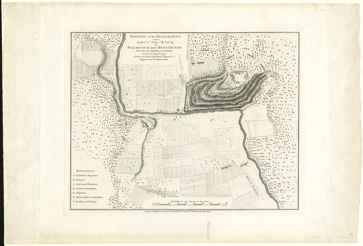
Position of the detachment under Lieut. Col. Baum, at Walmscock near Bennington shewing the attacks of the enemy on the 16th August 1777
This map is also available in American Revolutionary Geographies Online (ARGO), a collections portal especially built for material relating to the American Revolutionary War Era. Visit ARGO to learn more about this item and explore the historical geography of North America in the late eighteenth century.
Item Information
- Title:
- Position of the detachment under Lieut. Col. Baum, at Walmscock near Bennington shewing the attacks of the enemy on the 16th August 1777
- Creator:
- Durnford, Desmaretz, d. 1782
- Publisher:
- Faden, William, 1749-1836
- Name on Item:
-
Drawn by Lieutt. Durnford ; engraved by Wm. Faden.
- Date:
-
1780
- Format:
-
Maps/Atlases
- Location:
- George Washington's Mount Vernon
- Collection (local):
-
Richard H. Brown Revolutionary War Map Collection at Mount Vernon
- Subjects:
-
Bennington, Battle of, N.Y., 1777--Maps--Early works to 1800
Bennington (N.Y.)--History--Revolution, 1775-1783--Maps--Early works to 1800
- Places:
-
Wyoming (county)Bennington
- Extent:
- 1 map : hand col. ; 27 x 35 cm.
- Terms of Use:
-
No known copyright restrictions.
This work is licensed for use under a Creative Commons Attribution Non-Commercial Share Alike License (CC BY-NC-SA).

- Publisher:
-
London :
Publish'd as the Act directs ... by W. Faden ...
- Scale:
-
Scale [1:12,000]
- Language:
-
English
- Catalog Record:
-
MVLA record
- Notes:
-
Relief shown by hachures.
Shows deployment of divisions; roads, rivers, forests, fields and camps.
- Identifier:
-
06_01_008215

![[A map of part of Pennsylvania & Maryland intended to shew, at one view, the several places proposed for opening a communication between the waters of the Delaware & Chesopeak Bays]](https://bpldcassets.blob.core.windows.net/derivatives/images/commonwealth:z603vt12v/image_thumbnail_300.jpg)


