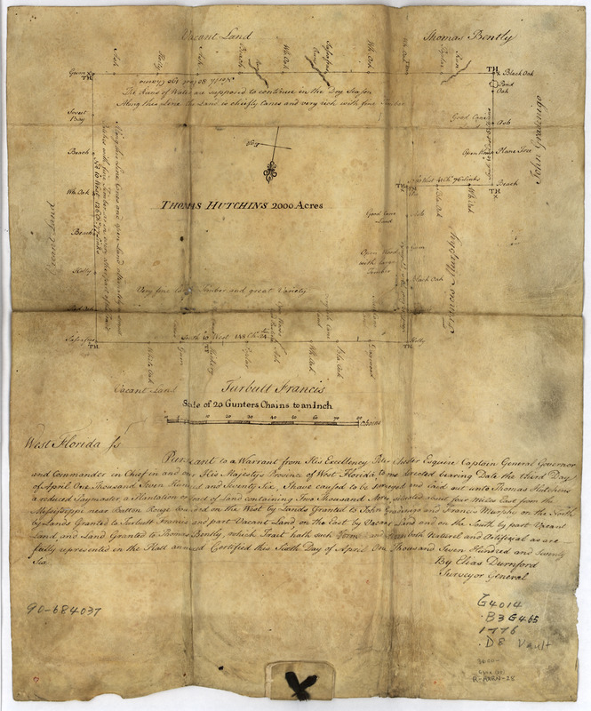
Thomas Hutchins' land grant and map to 2000 acres in West Florida
This map is also available in American Revolutionary Geographies Online (ARGO), a collections portal especially built for material relating to the American Revolutionary War Era. Visit ARGO to learn more about this item and explore the historical geography of North America in the late eighteenth century.
Item Information
- Title:
- Thomas Hutchins' land grant and map to 2000 acres in West Florida
- Title (alt.):
-
British patent to T. Hutchins, 1776, of 2000 a. of land in Florida
- Creator:
- Durnford, Elias Walker, active 1770-1794
- Name on Item:
-
by Elias Durnford, Surveyor General
- Date:
-
[1776]
- Format:
-
Maps/Atlases
Manuscripts
- Location:
- Library of Congress Geography and Map Division
- Collection (local):
-
Library of Congress Collection
- Subjects:
-
Land grants--Louisiana--Baton Rouge Suburban Area--Early works to 1800
Baton Rouge Suburban Area (La.)--Maps, Manuscript--Early works to 1800
Hutchins, Thomas
- Places:
-
East Baton Rouge (county)Baton Rouge
- Extent:
- 1 map : ms., vellum ; on sheet 40 x 33 cm., folded to 18 x 13 cm.
- Terms of Use:
-
No known copyright restrictions.
This work is licensed for use under a Creative Commons Attribution Non-Commercial Share Alike License (CC BY-NC-SA).

- Scale:
-
Scale [1:15,640]
- Language:
-
English
- Catalog Record:
-
https://lccn.loc.gov/90684037
- Notes:
-
Shows land grant 4 miles east of the Mississippi River "slightly removed from Baton Rouge."
Title from vendor's letter.
Panel title: British patent to T. Hutchins, 1776, of 2000 a. of lands in Florida.
Date of "June 26, 1841" and indecipherable signature also on panel.
Oriented with north toward the lower edge.
Pen-and-ink.
Imperfect: Holes along fold lines.
Includes text.
"2443."
- Notes (date):
-
This date is inferred.
- Identifier:
-
ct000671r


