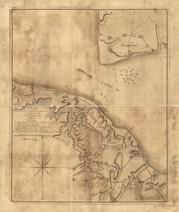
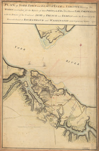
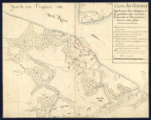
A Plan of the entrance of Chesapeak [sic] Bay, with James and York Rivers : wherein are shewn the respective positions (in the beginning of October) 1. of the British Army commanded by Lord Cornwallis, at Gloucester and York in Virginia; 2. of the American and French forces under General Washington, 3. and of the French fleet under Count de Grasse
![A Plan of the entrance of Chesapeak [sic] Bay, with James and York Rivers](https://bpldcassets.blob.core.windows.net/derivatives/images/commonwealth:q524nf233/image_access_800.jpg)
This map is also available in American Revolutionary Geographies Online (ARGO), a collections portal especially built for material relating to the American Revolutionary War Era. Visit ARGO to learn more about this item and explore the historical geography of North America in the late eighteenth century.
Item Information
- Title:
- A Plan of the entrance of Chesapeak [sic] Bay, with James and York Rivers : wherein are shewn the respective positions (in the beginning of October) 1. of the British Army commanded by Lord Cornwallis, at Gloucester and York in Virginia; 2. of the American and French forces under General Washington, 3. and of the French fleet under Count de Grasse
- Title (alt.):
-
Chesapeake Bay
- Name on Item:
-
By an officer
- Date:
-
[1781]
- Format:
-
Maps/Atlases
Manuscripts
- Location:
- Library of Congress Geography and Map Division
- Collection (local):
-
Library of Congress Collection
- Subjects:
-
Yorktown (Va.)--History--Siege, 1781--Maps, Manuscript--Early works to 1800
- Places:
-
York (county)Yorktown
- Extent:
- 1 manuscript map : hand color 41 x 53 cm.
- Terms of Use:
-
No known copyright restrictions.
This work is licensed for use under a Creative Commons Attribution Non-Commercial Share Alike License (CC BY-NC-SA).

- Scale:
-
Scale ca. 1:240,500
- Language:
-
English
- Catalog Record:
-
https://lccn.loc.gov/gm71000687
- Notes:
-
Manuscript, pen-and-ink.
Depths shown by soundings.
Annotated "London, Published by Wm. Faden, Charing Cross, Novr. 26th 1781."
- Notes (date):
-
This date is inferred.
- Notes (citation):
-
LC Maps of North America, 1750-1789, 1464
- Identifier:
-
ct000189