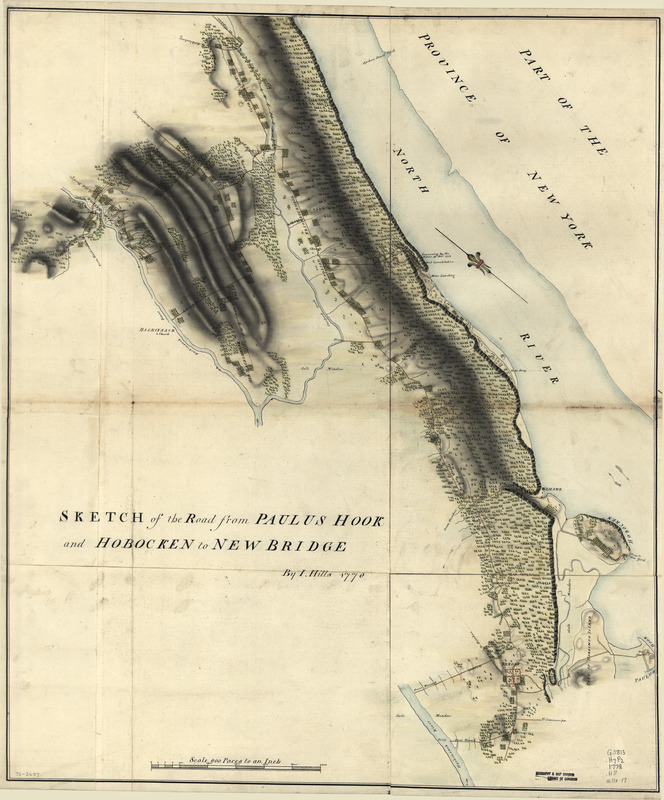
Sketch of the road from Paulus Hook and Hobocken to New Bridge
This map is also available in American Revolutionary Geographies Online (ARGO), a collections portal especially built for material relating to the American Revolutionary War Era. Visit ARGO to learn more about this item and explore the historical geography of North America in the late eighteenth century.
Item Information
- Title:
- Sketch of the road from Paulus Hook and Hobocken to New Bridge
- Title (alt.):
-
Paulus Hook and Hobocken to New Bridge
New Bridge
- Creator:
- Hills, John, (Surveyor)
- Contributor:
- Morgan, Benjamin, (Draftsman)
- Name on Item:
-
By I. Hills
- Date:
-
1778
- Format:
-
Maps/Atlases
Manuscripts
- Location:
- Library of Congress Geography and Map Division
- Collection (local):
-
Library of Congress Collection
- Subjects:
-
Roads--New Jersey--Hudson County--Maps--Early works to 1800
Roads--New Jersey--Paulus Hook Region--Maps--Early works to 1800
Manuscript maps--Early works to 1800
Hudson County (N.J.)--Maps--Early works to 1800
Paulus Hook (N.J.)--Maps--Early works to 1800
- Places:
-
Hudson (county)Jersey City
- Extent:
- 1 manuscript map : hand color ; 72 x 61 cm.
- Terms of Use:
-
No known copyright restrictions.
This work is licensed for use under a Creative Commons Attribution Non-Commercial Share Alike License (CC BY-NC-SA).

- Scale:
-
Scale ca. 1:24,000
- Language:
-
English
- Catalog Record:
-
https://lccn.loc.gov/gm72003607
- Notes:
-
Manuscript, pen-and-ink and watercolor.
Has watermarks.
Oriented with north toward the upper left.
Relief shown pictorially and by shading.
Authorship attributed to B. Morgan and J. Hills in the table of contents of the collection.
Includes note Fort Constitution "Evacuated by the rebels, 18th Novr. 1776."
Accompanied by Hills map collection title page and table of contents.
- Notes (citation):
-
LC Maps of North America, 1750-1789, 1285
- Identifier:
-
ar128500


