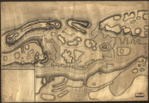
Plan of Governor's, Kennedy's, and Brown's Islan[ds] and Red Hook together with part of the Bay and soundings : shewing the position they bear to each other and to New York, September 18th. 1766. By order of His Excellency Major General Gage, Commander in Chief of His Majesty's forces in North America
![Plan of Governor's, Kennedy's, and Brown's Islan[ds] and Red Hook together with part of the Bay and soundings](https://bpldcassets.blob.core.windows.net/derivatives/images/commonwealth:q524nj614/image_access_800.jpg)
This map is also available in American Revolutionary Geographies Online (ARGO), a collections portal especially built for material relating to the American Revolutionary War Era. Visit ARGO to learn more about this item and explore the historical geography of North America in the late eighteenth century.
Item Information
- Title:
- Plan of Governor's, Kennedy's, and Brown's Islan[ds] and Red Hook together with part of the Bay and soundings : shewing the position they bear to each other and to New York, September 18th. 1766. By order of His Excellency Major General Gage, Commander in Chief of His Majesty's forces in North America
- Title (alt.):
-
Governor's, Kennedy's, and Brown's Islands
- Creator:
- Montrésor, John, 1736-1799
- Contributor:
- Porter, William B.
- Name on Item:
-
By John Montresor, engineer
- Date:
-
[1766]
- Format:
-
Maps/Atlases
Manuscripts
- Location:
- Library of Congress Geography and Map Division
- Collection (local):
-
Library of Congress Collection
- Subjects:
-
Harbors--New York (State)--New York--Maps--Early works to 1800
New York (N.Y.)--Maps, Manuscript--Early works to 1800
- Places:
-
New York
- Extent:
- 1 manuscript map : hand color 73 x 74 cm.
- Terms of Use:
-
No known copyright restrictions.
This work is licensed for use under a Creative Commons Attribution Non-Commercial Share Alike License (CC BY-NC-SA).

- Scale:
-
Scale 1:4,800
- Language:
-
English
- Catalog Record:
-
https://lccn.loc.gov/gm71000693
- Notes:
-
Manuscript, pen-and-ink and watercolor.
Has watermark.
Imperfect: Margins torn.
Relief shown by hachures. Soundings shown in fathoms.
Signed in different ink: W. B. Porter.
- Notes (date):
-
This date is inferred.
- Notes (citation):
-
LC Maps of North America, 1750-1789, 1086
- Identifier:
-
ar108600z