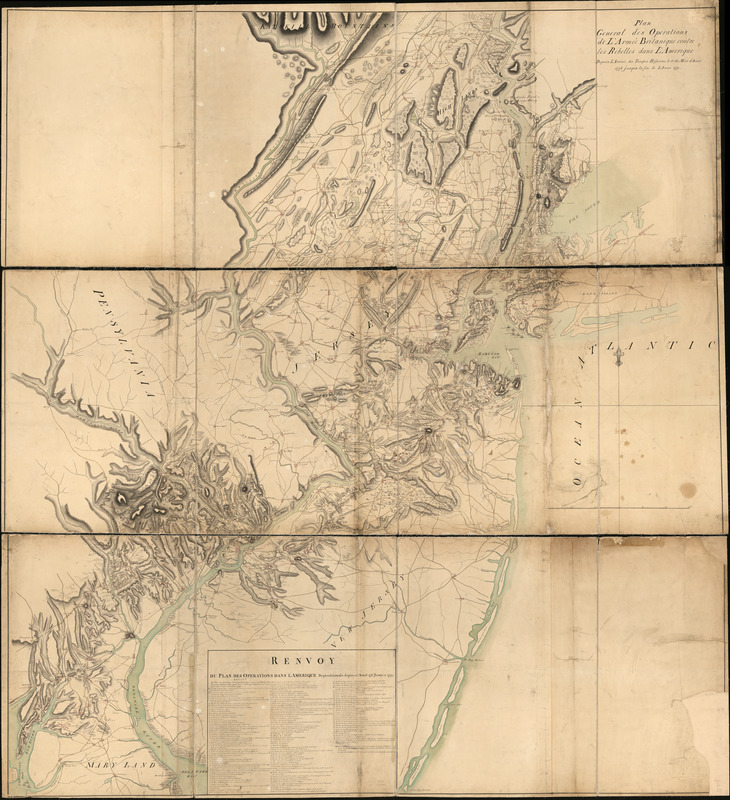
Plan general des operations de l'Armée Britanique contre les rebelles dans l'Amerique : depuis l'arrivée des troupes hessoises le 12 du mois d'aoust 1776 jusqu'à la fin de l'année 1779
This map is also available in American Revolutionary Geographies Online (ARGO), a collections portal especially built for material relating to the American Revolutionary War Era. Visit ARGO to learn more about this item and explore the historical geography of North America in the late eighteenth century.
Item Information
- Title:
- Plan general des operations de l'Armée Britanique contre les rebelles dans l'Amerique : depuis l'arrivée des troupes hessoises le 12 du mois d'aoust 1776 jusqu'à la fin de l'année 1779
- Creator:
- Gironcourt, Georges de
- Date:
-
[1780?]
- Format:
-
Maps/Atlases
Manuscripts
- Location:
- Library of Congress Geography and Map Division
- Collection (local):
-
Library of Congress Collection
- Subjects:
-
Northeastern States--History--Revolution, 1775-1783--British forces--Maps
- Places:
-
Northeastern United States (area)
- Extent:
- 1 manuscript map : hand color 211 x 194 cm. on 3 sheets 73 x 199 cm. in portfolio 74 x 60 cm.
- Terms of Use:
-
No known copyright restrictions.
This work is licensed for use under a Creative Commons Attribution Non-Commercial Share Alike License (CC BY-NC-SA).

- Scale:
-
Scale ca. 1:126,720
- Language:
-
French
- Catalog Record:
-
https://lccn.loc.gov/gm71000875
- Notes:
-
Relief shown by shading.
Manuscript, pen-and-ink and watercolor.
Covers area from West Point, N.Y. to Great Egg Harbor; Huntington and Jerusalem on Long Island to Chesapeake Bay and Sassafras River.
Inset: Renvoy du Plan des operations dans l'Amérique Septentrionale depuis 12me aoust 1776 jusu'a 1779.
Shows points of interest, troop movements, military emplacements and positions involving Hessian troops.
- Notes (citation):
-
LC Maps of North America, 1750-1789, 1059
- Identifier:
-
ar105900z


