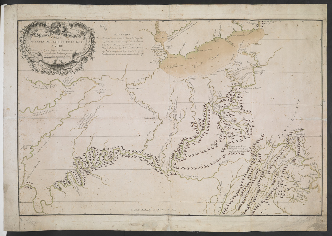
CARTE DU COURS DE L'OHIO OU DE LA BELLE RIVIERE : Depuis sa Source jusqu'a sa Jonction avec celle d'Ouabache, avec les pays les plus voisins
This map is also available in American Revolutionary Geographies Online (ARGO), a collections portal especially built for material relating to the American Revolutionary War Era. Visit ARGO to learn more about this item and explore the historical geography of North America in the late eighteenth century.
Item Information
- Title:
- CARTE DU COURS DE L'OHIO OU DE LA BELLE RIVIERE : Depuis sa Source jusqu'a sa Jonction avec celle d'Ouabache, avec les pays les plus voisins
- Description:
-
The map shows the Ohio and Wabash Rivers. Lake Erie is promient and detail extends eastwards as far as the Potomac River.
- Cartographer:
- Bellin, Jacques Nicolas, 1703-1772
- Former owner:
- Amherst, Jeffery Amherst, Baron, 1717-1797
- Former owner:
- Royal United Services Institute for Defence and Security Studies
- Date:
-
[ca. 1755]
- Format:
-
Maps/Atlases
- Location:
- British Library
- Collection (local):
-
British Library Collection
- Subjects:
-
Fortification--Erie, Lake--Maps, Manuscript--Early works to 1800
Ohio River--Maps, Manuscript--Early works to 1800
Wabash River--Maps, Manuscript--Early works to 1800
Erie, Lake--Maps, Manuscript--Early works to 1800
- Places:
-
Wabash River
Ohio River
Erie, Lake
- Extent:
- 1 map : manuscript pen and ink with watercolour ; 43 x 66 cm
- Terms of Use:
-
No known copyright restrictions.
This work is licensed for use under a Creative Commons Attribution Non-Commercial Share Alike License (CC BY-NC-SA).

- Publisher:
-
[Paris?] :
[Jacques Nicolas Bellin]
- Scale:
-
Scale approximately 1:1,100,000
- Language:
-
French
- Catalog Record:
-
http://searcharchives.bl.uk/IAMS_VU2:IAMS040-001999746
- Notes:
-
Date and cartographer attribution from comparison with manuscript map in the Bibliotheque Nationale de France which is signed and dated by Bellin - see GE C-5183. Detail on the two maps differs slightly and this example, unsigned and undated by the cartographer, has a more elaborate and decorative title cartouche.
Relief is shown pictorially.
Shows decorative title cartouche at upper left containing the scale bar, "Echelle de Lieues Communes de France".
Shows latitude and longitude, "Longitude Occidentale du Meridien de Paris".
Shows forts.
Copy at Add Ms 57,714.1. Bound in R.U.S.I. Vol LXXIX. Shows manuscript addition of "1" in pencil at upper right. Shows "A 30/93" in pencil at lower left and "A 54" at lower right. Laid on linen. Label (?) to verso showing "DRAWER 3 SECTION 2" obscured by linen.
- Notes (date):
-
9999

![[A coloured chart of the upper part of Lake Erie at Fort Erie and a detailed plan of Fort Erie, together with three cross sectional drawings]](https://bpldcassets.blob.core.windows.net/derivatives/images/commonwealth:hx11z482r/image_thumbnail_300.jpg)
![[Map of Fort Detroit and environs]](https://bpldcassets.blob.core.windows.net/derivatives/images/commonwealth:hx11xz63b/image_thumbnail_300.jpg)
![[A map of Lake Erie with the route southward from Fort Presqu'Isle to Fort Cumberland, with inset plans of Fort Pitt, Fort Venango, Fort Le Boeuf and Fort Presque Isle]](https://bpldcassets.blob.core.windows.net/derivatives/images/commonwealth:6108vw18h/image_thumbnail_300.jpg)
