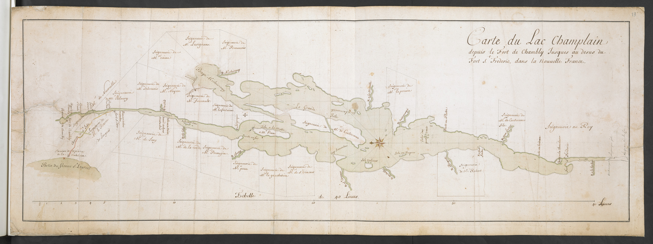
Carte du Lac Champlain depuis le Fort de Chambly Jusques au desus du Fort S.t Frederic, dans la Nouvelle France
This map is also available in American Revolutionary Geographies Online (ARGO), a collections portal especially built for material relating to the American Revolutionary War Era. Visit ARGO to learn more about this item and explore the historical geography of North America in the late eighteenth century.
Item Information
- Title:
- Carte du Lac Champlain depuis le Fort de Chambly Jusques au desus du Fort S.t Frederic, dans la Nouvelle France
- Former owner:
- Amherst, Jeffery Amherst, Baron, 1717-1797
- Former owner:
- Royal United Services Institute for Defence and Security Studies
- Date:
-
[1739–1759]
- Format:
-
Maps/Atlases
- Location:
- British Library
- Collection (local):
-
British Library Collection
- Subjects:
-
Land tenure--Champlain, Lake--Maps, Manuscript--Early works to 1800
Champlain, Lake--Maps, Manuscript--Early works to 1800
- Places:
-
Champlain, Lake
- Extent:
- 1 map on 2 sheets : joined, manuscript pen and ink with watercolour, over pencil ; 32 x 95 cm
- Terms of Use:
-
No known copyright restrictions.
This work is licensed for use under a Creative Commons Attribution Non-Commercial Share Alike License (CC BY-NC-SA).

- Publisher:
-
[Place of production not identified] :
[Producer not identified]
- Scale:
-
Scale approximately 1:176,000
- Language:
-
French
- Catalog Record:
-
http://searcharchives.bl.uk/IAMS_VU2:IAMS040-001999744
- Notes:
-
Labrosse suggested as cartographer from previous British Library cataloguing.
Date range suggested from comparison with a similar map "Carte du Lac Champlain depuis le Fort de Chambly Jusques au desus du Fort St Frederic dans la Nouvelle France" (provenance: Collection Moreau de Saint Méry) and listed within the Archives nationales d'outre-mer (see Cote : FR CAOM F3/290/59) with a date of 1739, and from other maps by Labrosse (dating between 1750 and 1760).
Shows forts.
Shows scale bar across the bottom of the map, "Echelle de 40 Lieues".
Shows landowners' names borddering Lake Champlain.
Shows a grid system in pencil on the map.
North is oriented to the left of the map and is indicated by a decorative compass rose in Lake Champlain.
Copy at Add Ms 57,712.13. Bound in R.U.S.I. Vol LXXVII. Shows manuscript addition of "13" in pencil at upper right. Laid on archival tissue. Green circular label to verso shows "7". White label to verso shows "DRAWER 29 SECTION 3". Blue label to verso shows "A 29/48", and repeated in pencil. Additional annotation to verso in pencil shows "A 72". Paper watermark shows a fleur de lys.
- Notes (date):
-
9999
This date is inferred.

![[A map of Lake Champlain and Lake George, showing the route from Fort Edward to Montreal]](https://bpldcassets.blob.core.windows.net/derivatives/images/commonwealth:hx11z3312/image_thumbnail_300.jpg)
![[A map of the southern part of the Lake Champlain, from "Tienderoga fort" to Crown Point]](https://bpldcassets.blob.core.windows.net/derivatives/images/commonwealth:6108vv78r/image_thumbnail_300.jpg)