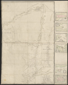
[Map showing Fort William Henry, Fort Carillon, Fort St Frederic, and the upper reaches of the Connecticut River]
![[Map showing Fort William Henry, Fort Carillon, Fort St Frederic, and the upper reaches of the Connecticut River]](https://bpldcassets.blob.core.windows.net/derivatives/images/commonwealth:hx11z1735/image_access_800.jpg)
This map is also available in American Revolutionary Geographies Online (ARGO), a collections portal especially built for material relating to the American Revolutionary War Era. Visit ARGO to learn more about this item and explore the historical geography of North America in the late eighteenth century.
Item Information
- Title:
- [Map showing Fort William Henry, Fort Carillon, Fort St Frederic, and the upper reaches of the Connecticut River]
- Former owner:
- Amherst, Jeffery Amherst, Baron, 1717-1797
- Former owner:
- Royal United Services Institute for Defence and Security Studies
- Date:
-
[ca. 1755]
- Format:
-
Maps/Atlases
- Location:
- British Library
- Collection (local):
-
British Library Collection
- Subjects:
-
Fortification--Pennsylvania--Maps, Manuscript--Early works to 1800
Fortification--New York (State)--Maps, Manuscript--Early works to 1800
Connecticut River--Maps, Manuscript--Early works to 1800
New York (State)--Maps, Manuscript--Early works to 1800
- Places:
-
Connecticut (river)
New York
Pennsylvania
- Extent:
- 1 map : manuscript pen and ink with watercolour ; 48 x 37 cm
- Terms of Use:
-
No known copyright restrictions.
This work is licensed for use under a Creative Commons Attribution Non-Commercial Share Alike License (CC BY-NC-SA).

- Publisher:
-
[Place of production not identified] :
[Producer not identified]
- Scale:
-
Scale not given
- Language:
-
French
- Catalog Record:
-
http://searcharchives.bl.uk/IAMS_VU2:IAMS040-001999744
- Notes:
-
Date from previous British Library cataloguing (and from forts shown).
Shows Native American nomenclature?
Shows settlements along the rivers only, no interior geography is shown.
Shows the overland path beween Lake Champlain and the Connecticut River ("Chemin quele sauvages [?]").
Copy at Add Ms 57,712.1. Bound in R.U.S.I. Vol LXXVII. Shows manuscript addition of "1" in pencil at upper right. Shows "A 27/40" in pencil at lower right and "A 64" at lower left. Laid on archival tissue. Green circular label to verso shows "18". White label to verso shows "DRAWER 27 SECTION 6". Blue label to verso shows "A 27/40". Illegible annotations to verso in pencil.
- Notes (date):
-
9999

![[A colored map of the route between Albany and Oswego; drawn about 1756, on a scale of 2 miles to an inch]](https://bpldcassets.blob.core.windows.net/derivatives/images/commonwealth:hx11z3223/image_thumbnail_300.jpg)
![[A map of Lake Erie with the route southward from Fort Presqu'Isle to Fort Cumberland, with inset plans of Fort Pitt, Fort Venango, Fort Le Boeuf and Fort Presque Isle]](https://bpldcassets.blob.core.windows.net/derivatives/images/commonwealth:6108vw18h/image_thumbnail_300.jpg)

