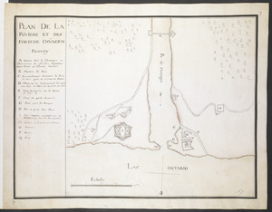
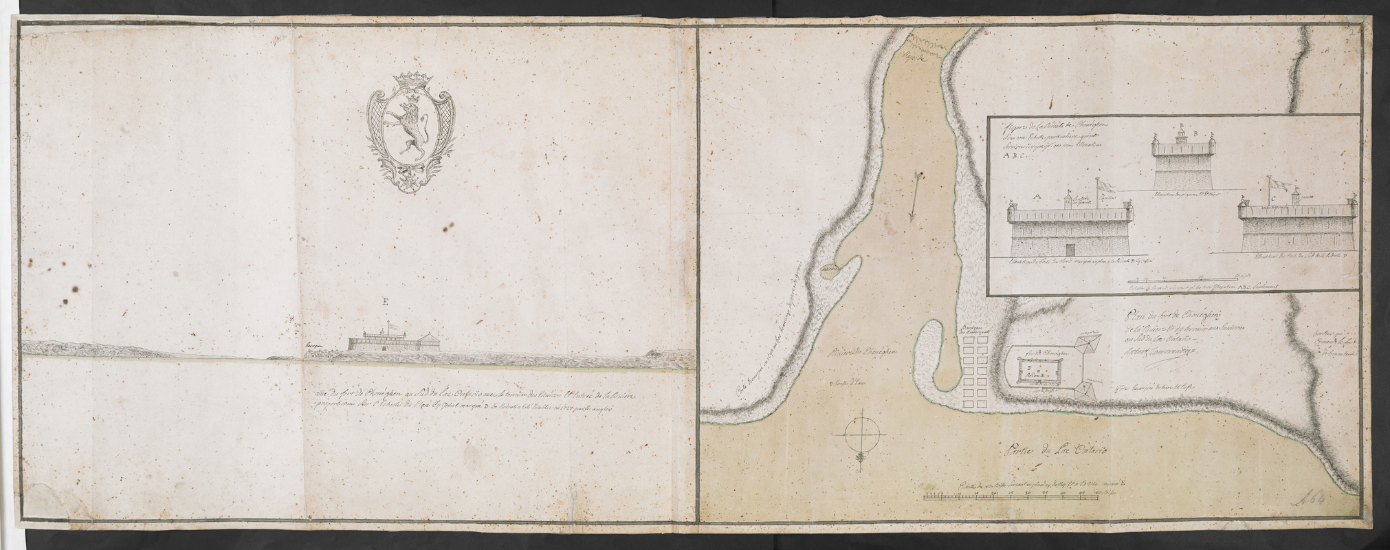
Plan du fort de Chouéghen de la Riviere Et de terrain aux Environs au Sud du Lac Ontario
This map is also available in American Revolutionary Geographies Online (ARGO), a collections portal especially built for material relating to the American Revolutionary War Era. Visit ARGO to learn more about this item and explore the historical geography of North America in the late eighteenth century.
Item Information
- Title:
- Plan du fort de Chouéghen de la Riviere Et de terrain aux Environs au Sud du Lac Ontario
- Cartographer:
- Rocbert Lamorendiere
- Former owner:
- Amherst, Jeffery Amherst, Baron, 1717-1797
- Former owner:
- Royal United Services Institute for Defence and Security Studies
- Name on Item:
-
Rocbert Lamorendiere.
- Date:
-
[1727–1756]
- Format:
-
Maps/Atlases
- Location:
- British Library
- Collection (local):
-
British Library Collection
- Subjects:
-
Fortification--New York (State)--Oswego--Maps, Manuscript--Early works to 1800
Military art and science----New York (State)--Oswego--Maps, Manuscript--Early works to 1800
Fort Oswego (Oswego, N.Y.)--Maps, Manuscript--Early works to 1800
- Places:
-
Oswego (county)Oswego
- Extent:
- 1 map on 2 sheets : joined, manuscript pen and ink with watercolour ; 40 x 111 cm
- Terms of Use:
-
No known copyright restrictions.
This work is licensed for use under a Creative Commons Attribution Non-Commercial Share Alike License (CC BY-NC-SA).

- Publisher:
-
[Place of production not identified] :
Rocbert Lamorendiere,
- Scale:
-
Scale approximately 1:680
- Language:
-
English
- Catalog Record:
-
http://searcharchives.bl.uk/IAMS_VU2:IAMS040-001999738
- Notes:
-
Shows Fort Chouagen (also known as Fort Oswego), suggesting date of production.
Relief is shown by shading.
North is oriented to the bottom of the map.
Shows title and "Rocbert Lamorendiere" at lower right.
Shows scale bar at lower right, "Echelle de 50 toises Servant au plan cy dessus Et a la Vuë marqué E".
Shows a view of the fort to the left including an unidentifeid coat of arms containins a crowned, rampant lion within a roundel, the whole surmounted by a crown; "Vue du fort de Chouéghen au Sud du Lac Ontario avec le terrain des Environ Et Entré de la Riviere proportionée Sur L'Echelle du Plan Cy Joint marquée D. La Redoute a esté Etablie en 1727 par les Anglois".
Shows inset elevation of the fort at upper right with their own scale bar (scale approximately 1:195).
Previous British Library cataloguing suggests Paul Labrosse as cartographer, but signature is of Rocbert Lamorendiere alone.
Copy at Add Ms 57,708.2. Bound in R.U.S.I. Vol LXXIII. Comprises 2 sheets, joined. Shows manuscript addition of "2" in pencil at upper right. Shows "A 64" in pencil at lower right (and repeated to verso). Laid on archival tissue. Green circular label to verso showing "14". White label to verso showing "DRAWER 30 SECTION 1". Blue label to verso showing "A 30/38" and repeated in pencil. Annotation in pencil adds Paul Labrosse's name.
- Notes (date):
-
9999
This date is inferred.