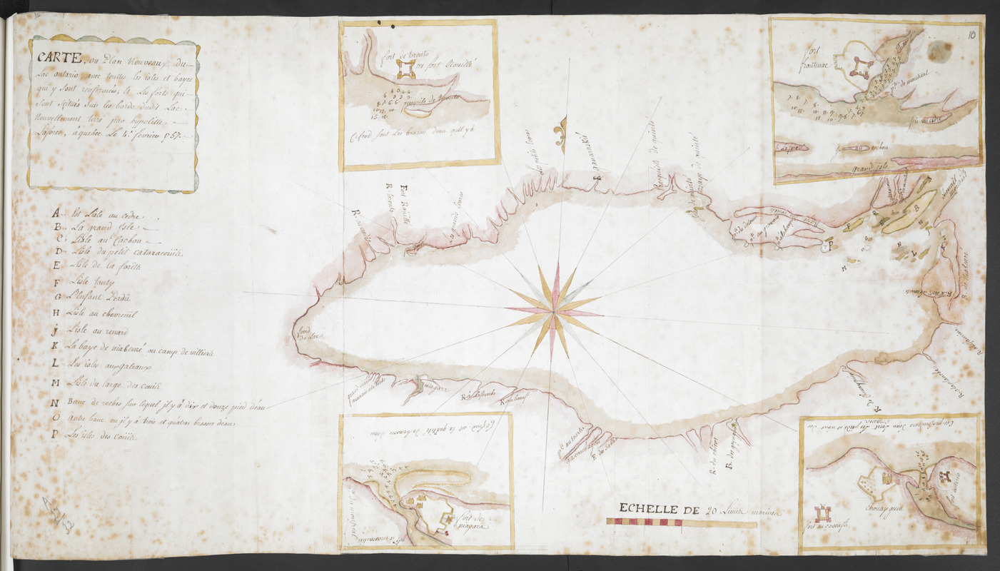
CARTE, ou plan Nouveau du Lac Ontario, avec touttes les isles et bayes qui y Sont rénfermées : Et les forts qui Sont Scitués Sur les bords du dit Lac
This map is also available in American Revolutionary Geographies Online (ARGO), a collections portal especially built for material relating to the American Revolutionary War Era. Visit ARGO to learn more about this item and explore the historical geography of North America in the late eighteenth century.
Item Information
- Title:
- CARTE, ou plan Nouveau du Lac Ontario, avec touttes les isles et bayes qui y Sont rénfermées : Et les forts qui Sont Scitués Sur les bords du dit Lac
- Cartographer:
- Laforce, René-Hippolyte, 1728-1802
- Former owner:
- Amherst, Jeffery Amherst, Baron, 1717-1797
- Former owner:
- Royal United Services Institute for Defence and Security Studies
- Name on Item:
-
nouvellement tirée par hypolitte Laforce, à quebec Le 4.e fevrier 1757.
- Date:
-
1757
- Format:
-
Maps/Atlases
- Location:
- British Library
- Collection (local):
-
British Library Collection
- Subjects:
-
Fortification--Ontario, Lake (N.Y. and Ont.)--Maps, Manuscript--Early works to 1800
Military art and science--Ontario, Lake (N.Y. and Ont.)--Maps, Manuscrip--Early works to 1800
Ontario, Lake (N.Y. and Ont.)--Maps, Manuscript--Early works to 1800
Fort Frontenac (Ont. : Fort)--Maps, Manuscript--Early works to 1800
Old Fort Niagara (N.Y.)--Maps, Manuscript--Early works to 1800
Fort Oswego (Oswego, N.Y.)--Maps, Manuscript--Early works to 1800
Fort Ontario (N.Y.)--Maps, Manuscript--Early works to 1800
- Places:
-
CanadaKingston
Oswego (county)Fort Oswego
Oswego (county)Fort Ontario
Niagara (county)Old Fort Niagara
Ontario, Lake
- Extent:
- 1 map on 2 sheets : manuscript pen and ink with watercolour ; 39 x 71 cm
- Terms of Use:
-
No known copyright restrictions.
This work is licensed for use under a Creative Commons Attribution Non-Commercial Share Alike License (CC BY-NC-SA).

- Publisher:
-
à quebec :
nouvellement tirée par hypolitte Laforce,
- Scale:
-
Scale approximately 1:1,030,000
- Language:
-
French
- Catalog Record:
-
http://searcharchives.bl.uk/IAMS_VU2:IAMS040-001999737
- Notes:
-
Shows title in a decorative cartouche at upper left with a lettered (A-P) key beneath identifying the islands of Lake Ontario.
Shows a decorative compass rose in the centre of the lake orienting north to the top of the map.
Shows a mileage scale at lower right, "ECHELLE DE 20 Lieue & marine".
Shows four inset maps at the corners of the map of Lake Ontario; Fort Toronto (also known as Fort Rouillé) at upper left, Fort Niagara at lower left, Fort Frontenac at upper right and Forts Ontario, Oswego (here called "Chouayguin") and George (here called [pejoratively] "Fort au Boeufs") at lower right.
Copy at Add Ms 57,707.10. Bound in R.U.S.I. Vol LXXII. Shows manuscript addition of "10" in pencil at upper right. Shows "A 27/32" in pencil at lower left. Laid on archival tissue. Manuscript addition of "A 66" to verso. Green circular label to verso showing "13". White label to verso showing "DRAWER 27 SECTION 3". Blue label to verso shows "A 27/32".
- Notes (date):
-
9999

![[Lake Ontario]](https://bpldcassets.blob.core.windows.net/derivatives/images/commonwealth:hx11xz576/image_thumbnail_300.jpg)

![Lake Ontario & River S.t Laurence from the Lake to Fort William Augustus in Three Rivers, this was taken from a French Draft that was on Board the Prise Williamson belonging to Monsr La Broquerie [east sheet]](https://bpldcassets.blob.core.windows.net/derivatives/images/commonwealth:hx11z135r/image_thumbnail_300.jpg)
