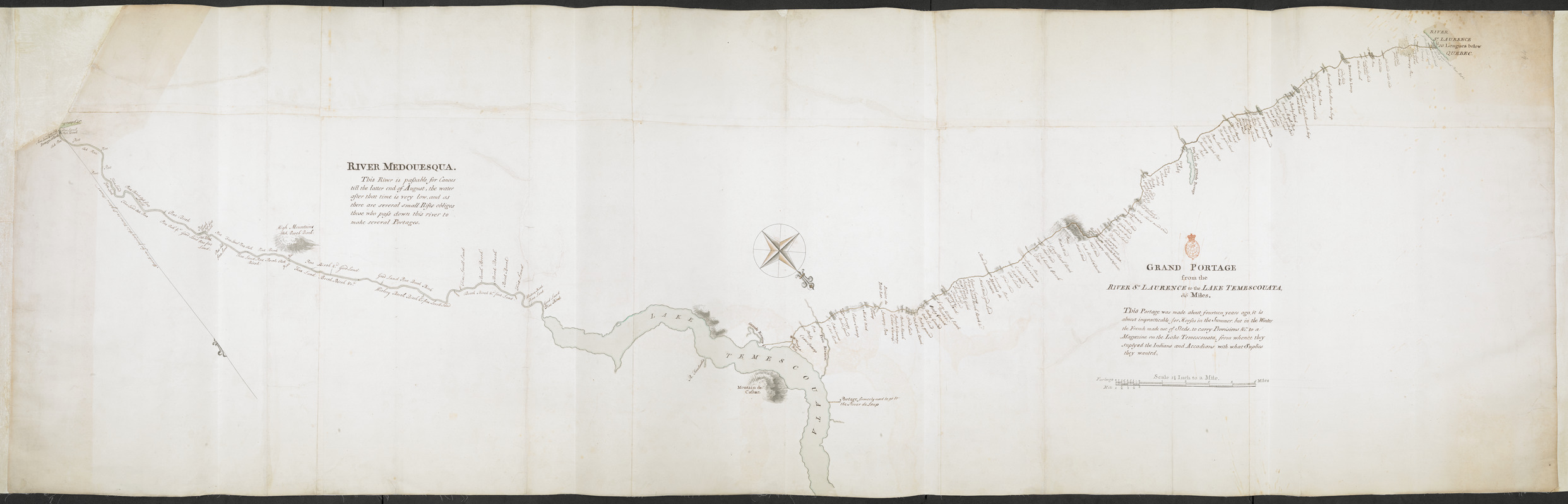
GRAND PORTAGE from the RIVER S.T LAURENCE to the LAKE TEMESCOUATA, 35 Miles : This Portage was made about fourteen years ago, it is almost impracticable for Horses in the Summer, but in the Winter the French made use of Sleds, to carry Provisions &c, to a Magazine on the Lake Temescouata, from when they suplyed the Indians and Accadians with what Suplies they wanted
This map is also available in American Revolutionary Geographies Online (ARGO), a collections portal especially built for material relating to the American Revolutionary War Era. Visit ARGO to learn more about this item and explore the historical geography of North America in the late eighteenth century.
Item Information
- Title:
- GRAND PORTAGE from the RIVER S.T LAURENCE to the LAKE TEMESCOUATA, 35 Miles : This Portage was made about fourteen years ago, it is almost impracticable for Horses in the Summer, but in the Winter the French made use of Sleds, to carry Provisions &c, to a Magazine on the Lake Temescouata, from when they suplyed the Indians and Accadians with what Suplies they wanted
- Former owner:
- Amherst, Jeffery Amherst, Baron, 1717-1797
- Former owner:
- Royal United Services Institute for Defence and Security Studies
- Date:
-
[1759?]
- Format:
-
Maps/Atlases
- Location:
- British Library
- Collection (local):
-
British Library Collection
- Subjects:
-
Roads--Québec (Province)--Maps, Manuscript--Early works to 1800
Lake Temiscouata--Québec (Province)--Maps, Manuscript--Early works to 1800--Maps, Manuscript--Early works to 1800
- Places:
-
CanadaTémiscouata, Lac (lake)
- Extent:
- 1 map on 10 sheets : joined, laid on linen, manuscript pen and ink with watercolour ; 74 x 234 cm
- Terms of Use:
-
No known copyright restrictions.
This work is licensed for use under a Creative Commons Attribution Non-Commercial Share Alike License (CC BY-NC-SA).

- Publisher:
-
[Place of production not identified] :
[producer not identified]
- Scale:
-
Scale approximately 1:46,000
- Language:
-
English
- Catalog Record:
-
http://searcharchives.bl.uk/IAMS_VU2:IAMS040-001999735
- Notes:
-
Date suggested after British control of the region had been gained at the end of the Saint John River campaign?
Relief shown by shading.
Shows the "Chemin du Portage" or trade route between Edmundston and the River St Lawrence.
Shows a decorative compass rose orienting north to the lower right of the map
Names timber species along the portage route.
Shows title centrally with "Scale 1 3/8 Inch to a Mile" beneath.
Shows a further textual note at upper left, "RIVER MEDOUESQUA. This River is passable for Canoes till the latter end of August, the water after that time is very low, and as there are several small Rifts obliges those who pass doen this river to make several Portages".
Copy at Add Ms 57,705.2. In a R.U.S.I. solander box numbered Vol LXX and LXXI. Comprises 10 sheets joined and laid on linen. Red stamp of R.U.S.I. above the title at lower centre. Shows manuscript addition of "C 44" in pencil at upper right. Green circular label to verso shows "14". White label to verso showing "DRAWER 27 SECTION 6". Blue label to the verso shows "A 27/39". Stamp to verso in black ink shows "ADD. MS. 57,705 (2). Manuscript additions to verso repeat the pressmark "57705-2" and "27/39".
- Notes (date):
-
9999


