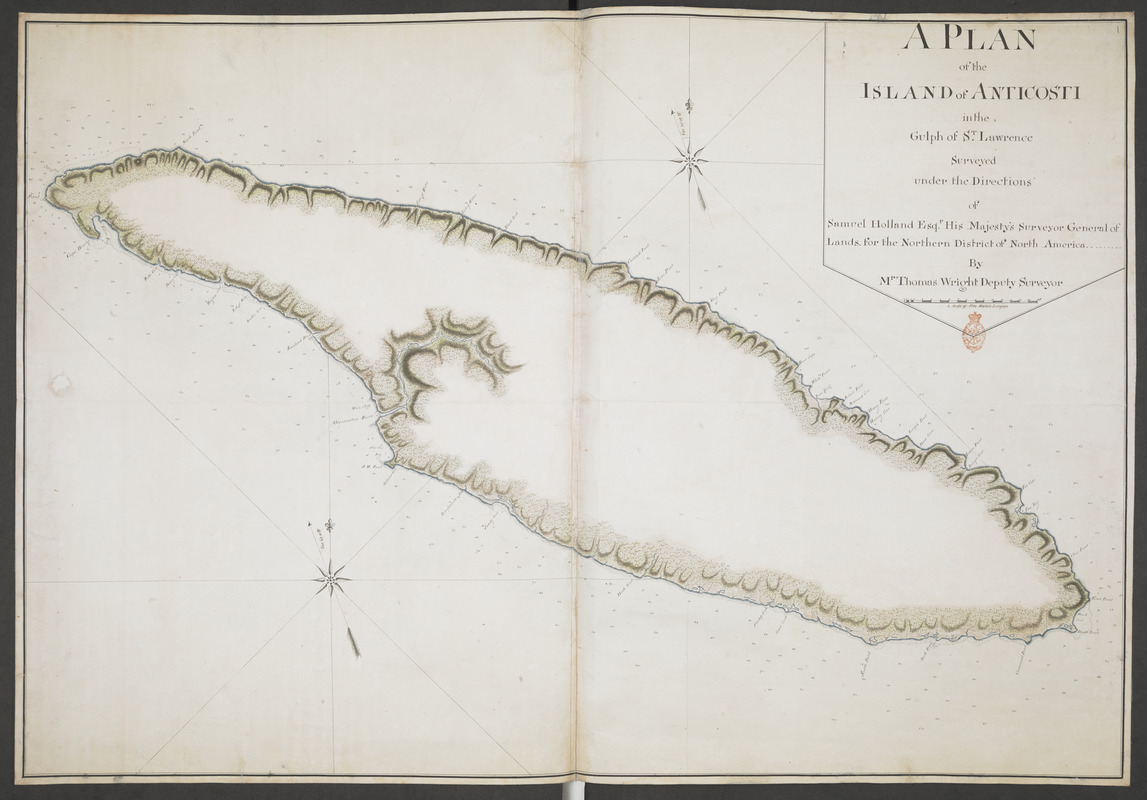
A PLAN of the ISLAND of ANTICOSTI in the Gulph of S.T Lawrence Surveyed under the Directions of Samuel Holland Esq.r His Majesty's Surveyor General of Lands for the Northern District of North America
This map is also available in American Revolutionary Geographies Online (ARGO), a collections portal especially built for material relating to the American Revolutionary War Era. Visit ARGO to learn more about this item and explore the historical geography of North America in the late eighteenth century.
Item Information
- Title:
- A PLAN of the ISLAND of ANTICOSTI in the Gulph of S.T Lawrence Surveyed under the Directions of Samuel Holland Esq.r His Majesty's Surveyor General of Lands for the Northern District of North America
- Surveyor:
- Wright, Thomas, surveyor general
- Associated name:
- Holland, Samuel, 1728-1801
- Former owner:
- Amherst, Jeffery Amherst, Baron, 1717-1797
- Former owner:
- Royal United Services Institute for Defence and Security Studies
- Name on Item:
-
By Mr Thomas Wright Deputy Surveyor.
- Date:
-
[1767]
- Format:
-
Maps/Atlases
- Location:
- British Library
- Collection (local):
-
British Library Collection
- Subjects:
-
Anticosti Island (Québec)--Maps, Manuscript--Early works to 1800
- Places:
-
CanadaAnticosti Island (island)
- Extent:
- 1 map on 2 sheets : joined, laid on linen, manuscript pen and ink with watercolour ; 71 x 104 cm
- Terms of Use:
-
No known copyright restrictions.
This work is licensed for use under a Creative Commons Attribution Non-Commercial Share Alike License (CC BY-NC-SA).

- Publisher:
-
[Halifax?] :
By Mr Thomas Wright Deputy Surveyor,
- Scale:
-
Scale approximately 1:195,000
- Language:
-
English
- Catalog Record:
-
http://searcharchives.bl.uk/IAMS_VU2:IAMS040-001999734
- Notes:
-
Date from Hornsby.
Compare also Maps K.Top.119.50. showing Passamaquoddy Bay, also surveyed by Thomas Wright, and annotated "Survey'd in the year 1772".
Relief shown by shading.
Shows sounding depths.
Geographical detail is limited to the coastline and rivers - no internal geography is shown.
Shows title in s simple surround at upper right including "A Scale of Five Statute Leagues".
Shows two decorative compass roses orienting north and magnetic north on the map.
Copy at Add Ms 57,704.1. Bound in R.U.S.I. Vol LXIX. Comprises 2 sheets joined and laid on linen. Shows red stamp of R.U.S.I. in title at upper right. Shows manuscript addition of "1" in pencil at upper right. Shows manuscript addition of "C 33" in pencil to verso. Green circular label to verso shows "1". White label to verso showing "DRAWER 27 SECTION 6". Blue label to verso shows "A 27/35", which is also repeated in pencil in a manuscript annotation.
- Notes (date):
-
9999
This date is inferred.


