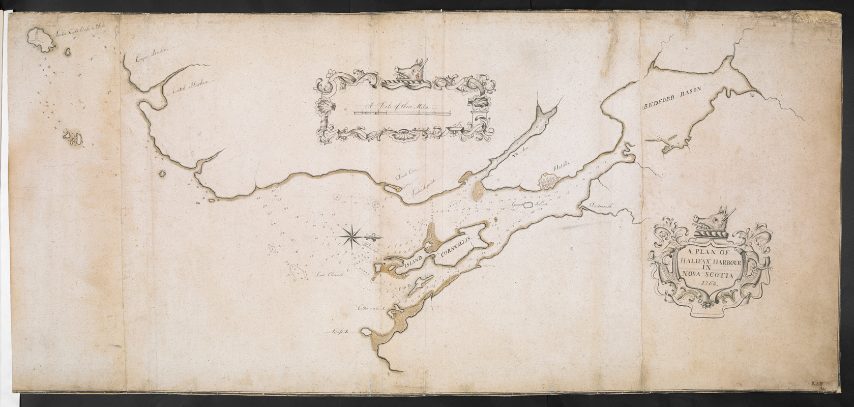
A PLAN OF HALIFAX HARBOUR IN NOVA SCOTIA 1760
This map is also available in American Revolutionary Geographies Online (ARGO), a collections portal especially built for material relating to the American Revolutionary War Era. Visit ARGO to learn more about this item and explore the historical geography of North America in the late eighteenth century.
Item Information
- Title:
- A PLAN OF HALIFAX HARBOUR IN NOVA SCOTIA 1760
- Signer:
- Davenport, R. A.
- Former owner:
- Royal United Services Institute for Defence and Security Studies
- Date:
-
[ca. 1760]
- Format:
-
Maps/Atlases
- Location:
- British Library
- Collection (local):
-
British Library Collection
- Subjects:
-
Harbors--Nova Scotia--Halifax--Maps, Manuscript--Early works to 1800
Halifax (N.S.)--Maps, Manuscript--Early works to 1800
- Places:
-
CanadaHalifax
- Extent:
- 1 map on 3 sheets : joined, manuscript pen and ink with wash colour over pencil, 47 x 104 cm
- Terms of Use:
-
No known copyright restrictions.
This work is licensed for use under a Creative Commons Attribution Non-Commercial Share Alike License (CC BY-NC-SA).

- Publisher:
-
[Place of production not identified] :
[producer not identified]
- Scale:
-
Scale approximately 1:38,600
- Language:
-
English
- Catalog Record:
-
http://searcharchives.bl.uk/IAMS_VU2:IAMS040-001999732
- Notes:
-
Date attributed from title. Addition in ink at lower right showing "RAD 1820" suggests a subsequent owner? Compare also Add. Ms. 57.702.2 showing Halifax Harbour and also inscribed "RAD 1820" at lower right [this map also has a manuscript addition to verso in ink - "R A Davenport 1830"]. Could Richard Alfred Davenport (known as a writer and based in London) have been the cartographer of this map? Was he copying an earlier 1760 map? Stylistically, the map could have been produced in Halifax and later came into Davenport's possession.
Sounding depths are given.
Shows title in a decorative cartouche, surmounted by a boar's head - staked and bleeding, at lower right.
Shows "A Scale of three Miles" at upper centre within a decorative cartouche, also surmounted by a boar's head - staked and bleeding.
Shows a decorative compass rose within Halifax Harbour orienting north to the right of the map.
Shows the lighthouse at Sambro Head pictorially.
Compare with the Charles Morris survey of Halifax Harbour published by Thomas Jefferys (see Maps 1.Tab.44. for an example of the published map bound in an atlas within the King's Topographical Collection).
See Add. Ms. 57.702.2. for another map with the signature "RAD".
Copy at Add Ms 57,702.1. Bound in R.U.S.I. Vol LXVII. Comprises 3 sheets, joined. Shows manuscript addition of "1" in pencil at upper right. Green circular sticker to verso with "1". Additional white label to verso showing "DRAWER 28 SECTION 2". Additional manuscript addition in pencil to verso showing "A 28/32".
- Notes (date):
-
9999