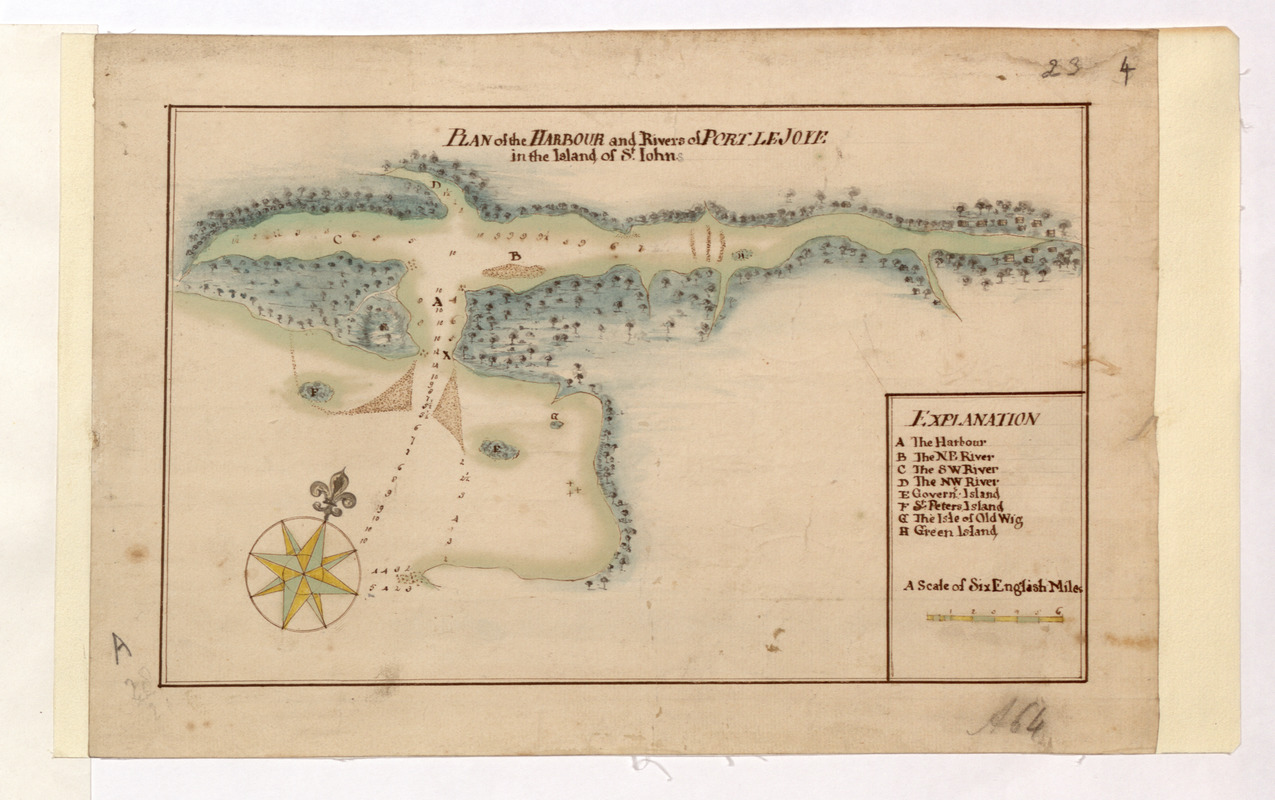
PLAN of the HARBOUR and Rivers of PORT LE JOYE in the Island of S.t Iohn
This map is also available in American Revolutionary Geographies Online (ARGO), a collections portal especially built for material relating to the American Revolutionary War Era. Visit ARGO to learn more about this item and explore the historical geography of North America in the late eighteenth century.
Item Information
- Title:
- PLAN of the HARBOUR and Rivers of PORT LE JOYE in the Island of S.t Iohn
- Former owner:
- Amherst, Jeffery Amherst, Baron, 1717-1797
- Former owner:
- Royal United Services Institute for Defence and Security Studies
- Date:
-
[1750–1765]
- Format:
-
Maps/Atlases
- Location:
- British Library
- Collection (local):
-
British Library Collection
- Subjects:
-
Harbors--Prince Edward Island--Port-la-Joye--Fort Amherst National Historic Site (P.E.I.)--Maps, Manuscript--Early works to 1800
Port-la-Joye--Fort Amherst National Historic Site (P.E.I.)--Maps, Manuscript--Early works to 1800
- Places:
-
CanadaFort Amherst National Historic Park (historical park)
- Extent:
- 1 map : manuscript pen and ink with watercolour ; 17 x 26 cm
- Terms of Use:
-
No known copyright restrictions.
This work is licensed for use under a Creative Commons Attribution Non-Commercial Share Alike License (CC BY-NC-SA).

- Publisher:
-
[Place of production not identified] :
[producer not identified]
- Scale:
-
Scale approximately 1:253,440
- Language:
-
English
- Catalog Record:
-
http://searcharchives.bl.uk/IAMS_VU2:IAMS040-001999731
- Notes:
-
Sounding depths are given.
Date attributed on stylistic grounds and prior to the appointment of Samuel Holland as Surveyor General of North America from 1764 when Prince Edward Island was mapped in detail. However, Fort Amherst is not shown or named although this was completed in 1758.
Shows title at top of map.
Shows "A Scale of six English Miles" at lower right.
Shows a lettered key ( A-H) at lower right naming "Govern's Island", "S.t Peters Island", "The Isle of Old Wig" and "Green Island".
Shows a decorative compass rose at lower left orienting north to the top of the map.
Copy at Add Ms 57,701.4. Bound in R.U.S.I. Vol LXVI. Manuscript addition of "A64" in pencil in margin at lower right. Manuscript addition of "A 28/2" at in pencil in margin at lower left. Manuscript addition of "23 4" in pencil in margin at upper right. Laid on linen. Green circular sticker to verso with "40". Additional white label to verso showing "DRAWER 28 SECTION 2". Shows "23" in pencil to verso beneath linen. Paper watermark shows a fleur de lys.
- Notes (date):
-
9999
This date is inferred.


