[Map showing neck of land between 'Baye francaise' and 'Baye verte']
![[Map showing neck of land between 'Baye francaise' and 'Baye verte']](https://bpldcassets.blob.core.windows.net/derivatives/images/commonwealth:hx11z035j/image_access_800.jpg)
This map is also available in American Revolutionary Geographies Online (ARGO), a collections portal especially built for material relating to the American Revolutionary War Era. Visit ARGO to learn more about this item and explore the historical geography of North America in the late eighteenth century.
Item Information
- Title:
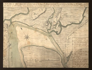
- [Map showing neck of land between 'Baye francaise' and 'Baye verte']
- Former owner:
- Amherst, Jeffery Amherst, Baron, 1717-1797
- Former owner:
- Royal United Services Institute for Defence and Security Studies
- Date:
-
[ca. 1751]
- Format:
-
Maps/Atlases
- Location:
- British Library
- Collection (local):
-
British Library Collection
- Subjects:
-
Fortification--Chignecto Isthmus (N.B. and N.S.)--Maps, Manuscript--Early works to 1800
Military art and science--Chignecto Isthmus (N.B. and N.S.)--Maps, Manuscript--Early works to 1800
Chignecto Isthmus (N.B. and N.S.)--Maps, Manuscript--Early works to 1800
- Places:
-
Chignecto Isthmus
- Extent:
- 1 map : manuscript pen and ink with watercolour ; 47 x 66 cm
- Terms of Use:
-
No known copyright restrictions.
This work is licensed for use under a Creative Commons Attribution Non-Commercial Share Alike License (CC BY-NC-SA).

- Publisher:
-
[Place of production not identified] :
[producer not identified]
- Scale:
-
Scale approximately 1:205,000
- Language:
-
French
- Catalog Record:
-
http://searcharchives.bl.uk/IAMS_VU2:IAMS040-001999732
- Notes:
-
Title supplied from "The British Library catalogue of additions to the manuscripts, new series 1971-1975".
Date suggested from comparison with "Carte du fond de la Baye Française et de la Baye Verte où sont marqués les forts construit par les Français et Anglais en 1750 et 1751" annotated to the verso with "Jointe à la lettre de M. de la Jonquière du 10 8bre 1751" and stamped by "Dépôt des Fortifications des Colonies" (held by the Archives nationales d'outre-mer - FR CAOM 03DFC43B). Both maps show similar nomenclature, although there are also marked differences.
Shows the forts and defences built by the English and French in the region. Names "Beausejour" "Gaspareaux", shows "Beaubassin" (for Fort Lawrence) and shows an unnamed fort at Saint John (Fort Frederick).
Shows a scale of "Lieues" at lower centre.
Shows the "portage" from the "Bay Francaises" to the Saint Lawrence River.
Compare also Maps K.Top.119.62. - shows the same region and also by an anonymous French mapmaker.
Copy at Add Ms 57,702.17. Bound in R.U.S.I. Vol LXVII. Shows manuscript addition of "17" in pencil at upper right. Shows manuscript addition of "A 57" in pencil at lower right. Shows manuscript addition of "A 28/55" in pencil at lower left. Laid on archival tissue. Green circular label to verso showing "30". White label to verso showing "DRAWER 28 SECTION 2". Blue label to verso shows "A 28/55". Manuscript addition of "17" in pencil to verso. Manuscript additions in ink to verso "41 Cr2 (?), "27-24" and "49-12". Inscribed "For His Excellency Gen. Amherst" in ink to verso.
- Notes (date):
-
9999