Plan of the Harbour of St John's in the Bay of Fundy= Plan & Section of the Fort as it is Near Finish'd= Plan & Section's of the Remains of the old French Fort
This map is also available in American Revolutionary Geographies Online (ARGO), a collections portal especially built for material relating to the American Revolutionary War Era. Visit ARGO to learn more about this item and explore the historical geography of North America in the late eighteenth century.
Item Information
- Title:
- Plan of the Harbour of St John's in the Bay of Fundy= Plan & Section of the Fort as it is Near Finish'd= Plan & Section's of the Remains of the old French Fort
- Associated name:
- Monckton, Robert, 1726-1782
- Former owner:
- Amherst, Jeffery Amherst, Baron, 1717-1797
- Former owner:
- Royal United Services Institute for Defence and Security Studies
- Date:
-
1758
- Format:
-
Maps/Atlases
- Location:
- British Library
- Collection (local):
-
British Library Collection
- Subjects:
-
Fortification--New Brunswick--Saint John--Maps, Manuscript--Early works to 1800
Military art and science--New Brunswick--Saint John--Maps, Manuscript--Early works to 1800
Saint John (N.B.)--Maps, Manuscript--Early works to 1800
- Places:
-
CanadaSaint John
- Extent:
- 3 maps on 3 sheets : manuscript pen and ink with watercolour ; sheets 38 x 49 cm or smaller
- Terms of Use:
-
No known copyright restrictions.
This work is licensed for use under a Creative Commons Attribution Non-Commercial Share Alike License (CC BY-NC-SA).

- Publisher:
-
[Fort Frederick?] :
[producer not identified]
- Scale:
-
Scales differ
- Language:
-
English
- Catalog Record:
-
http://searcharchives.bl.uk/IAMS_VU2:IAMS040-001999732
- Notes:
-
3 maps on 3 separate sheets, all by different hands and all by an unidentified cartographer, but united by the same annotation to the verso of each sheet in ink "Enclosed in Col. Monkton's of the 15.th Oct: 1758" and showing evidence of having been similarly folded for despatch. Each sheet bears the watermark and/or countermark of a fleur de lys within a shield with "LVG" beneath, and "IV". The two smaller sheets are each half the size of the larger, third sheet.
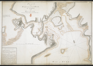
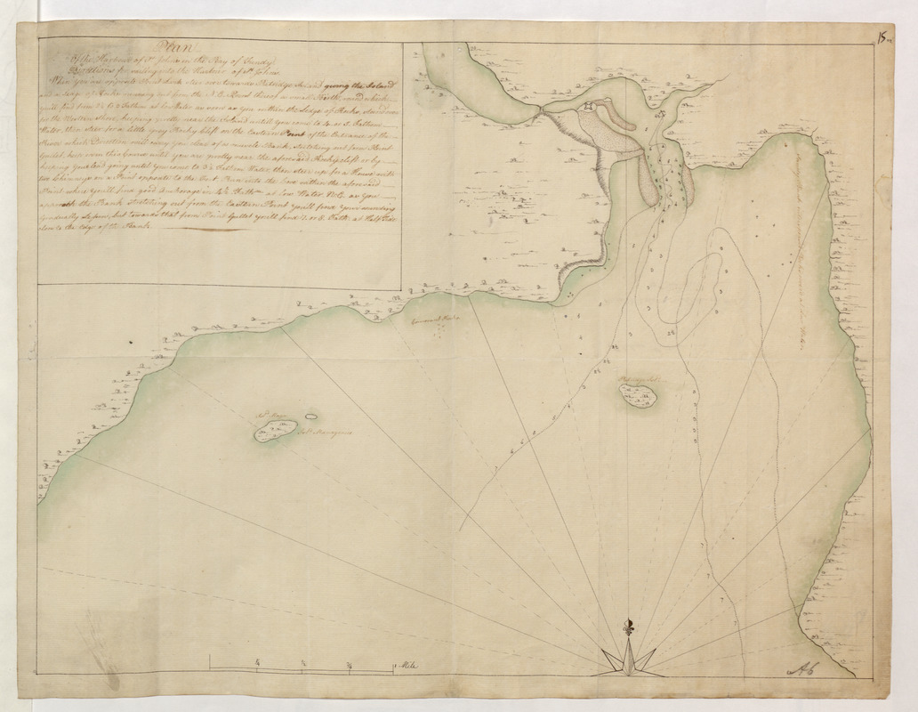
"Plan of the Harbour of St John's in the Bay of Fundy" shows the title at upper left with extensive textual sailing directions beneath. Relief is shown pictorially and sounding depths are given. Geographic detail extends in the Bay of Fundy to include Manawagonish Island and Thumb Cap Island. A scale bar is given at lower left showing 1/4 mile to an inch (scale approximately 1:15,840). Manuscript additions in pencil show "A 26" at lower left and "15 02" at upper right. Laid on archival tissue. Manuscript annotation in ink to verso shows "St John's Harbour Enclosed in Col. Monkton's of the 15.th Oct: 1758". Manuscript addition to verso in pencil shows "A 28/40A". Green circular label to verso shows "15". White label to verso showing "DRAWER 28 SECTION 2". Blue label to verso shows "A 28/40". Sheet measures 38 x 49 cm.
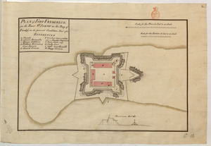
"Plan & Section of the Fort as it is Near Finish'd" shows the title at upper left with a lettered key (A-G) beneath identifying locations within the fort. The key ends with a decorative flourish or perhaps the cartographer's initials? A scale in feet is given at upper right showing 40 feet to an inch (scale approximately 1:480). Beneath the plan of the fort art two profiles with a separate scale showing 20 feet to an inch (scale approximately 1:240). Manuscript additions in pencil show "A6" at lower right and "14*" at upper right (should show "15*"). Laid on archival tissue. Manuscript annotation in ink to verso shows "Fort as nearly Compleated - Enclosed in Col. Monkton's of the 15.th Oct: 1758". Manuscript addition to verso in pencil shows "A 28/40A". Green circular label to verso shows "16 3". Manuscript addition in pencil shows "Drawer 26 Sec 2". Sheet measures 38 x 25 cm.
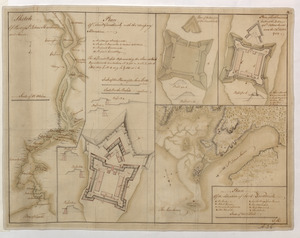
" Plan & Section's of the Remains of the old French Fort" shows the title at upper centre. Four profile drawings are given to the right of the plan. Scales beneath the map are given in feet for the profiles (scale approximately 1:240) and the plan (1:480). Manuscript additions in pencil show "A6" at lower right and "14**" at upper right (should show "15**"). Laid on archival tissue. Manuscript annotation in ink to verso shows "Remains of the Old French Fort - Enclosed in Col. Monkton's of the 15.th Oct: 1758". Manuscript addition to verso in pencil shows "A 28/40A". Green circular label to verso shows "16 3". Manuscript addition in pencil shows "Drawer 26 Sec 2". Sheet measures 38 x 25 cm.
- Notes (date):
-
9999