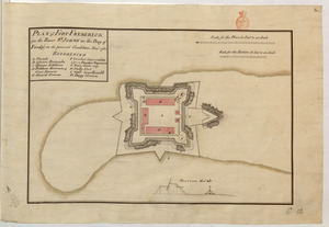
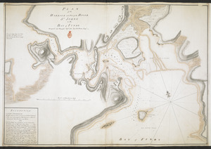
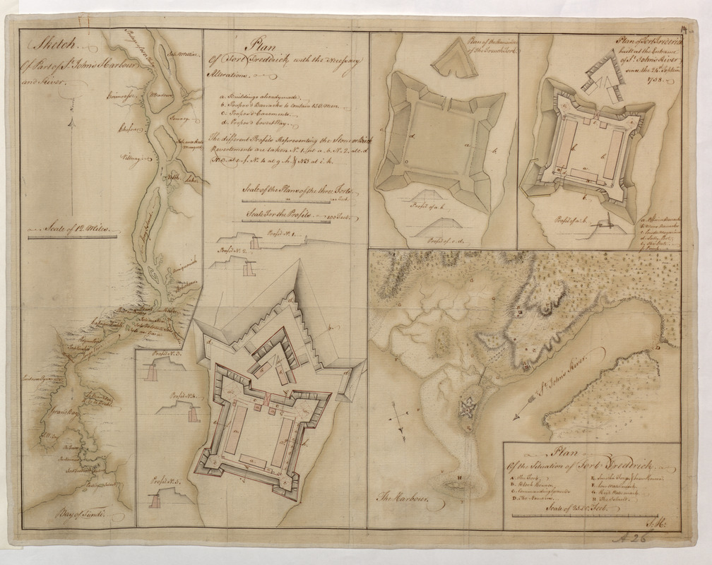
Sketch Of Part of S.t John's Harbour and River= Plan of Fort Frederick with the Necessary Alterations= Plan of the Ramainder of the French Fort= Plan of Fort Frederick built at the Entrance of S.t John's River since the 24.th Septemr 1758.= Plan Of the Situation of Fort Frederick
This map is also available in American Revolutionary Geographies Online (ARGO), a collections portal especially built for material relating to the American Revolutionary War Era. Visit ARGO to learn more about this item and explore the historical geography of North America in the late eighteenth century.
Item Information
- Title:
- Sketch Of Part of S.t John's Harbour and River= Plan of Fort Frederick with the Necessary Alterations= Plan of the Ramainder of the French Fort= Plan of Fort Frederick built at the Entrance of S.t John's River since the 24.th Septemr 1758.= Plan Of the Situation of Fort Frederick
- Cartographer:
- S.H.
- Former owner:
- Amherst, Jeffery Amherst, Baron, 1717-1797
- Former owner:
- Royal United Services Institute for Defence and Security Studies
- Name on Item:
-
S:H:.
- Date:
-
[1758]
- Format:
-
Maps/Atlases
- Location:
- British Library
- Collection (local):
-
British Library Collection
- Subjects:
-
Fortification--New Brunswick--Saint John--Maps, Manuscript--Early works to 1800
Military art and science--New Brunswick--Saint John--Maps, Manuscript--Early works to 1800
Saint John (N.B.)--Maps, Manuscript--Early works to 1800
- Places:
-
CanadaSaint John
- Extent:
- 5 maps on 1 sheet : manuscript pen and ink with watercolour ; sheet 39 x 50 cm
- Terms of Use:
-
No known copyright restrictions.
This work is licensed for use under a Creative Commons Attribution Non-Commercial Share Alike License (CC BY-NC-SA).

- Publisher:
-
[Fort Frederick?] :
S:H:,
- Scale:
-
Scales differ
- Language:
-
English
- Catalog Record:
-
http://searcharchives.bl.uk/IAMS_VU2:IAMS040-001999732
- Notes:
-
Shows 5 maps on 1 sheet.
Shows "Sketch Of Part of S.t Johns Harbour and River" on the left of the sheet including a "Scale of 12 Miles" (scale approximately 1:297,000). The map extends from the Bay of Fundy northwards to Grand Lake. Fort Frederick is named.
Shows "Plan of Fort Frederick with the Necessary Alterations" to the left of the sheet's centre. A lettered key (a-d) identifies buildings already made within the fort, proposed barracks, proposed casements and a proposed "Covert Way". Also included are five sections through the fort accompanied by a textual note identifying their location. Scales are given in feet as "Scale of the Plans of the three Forts" (scale approximately 1:960 )and "Scale for the Profiles" (scale approximately 1:480).
Shows "Plan of the Ramainder of the French Fort" (previously known as Fort Menagoueche) and "Plan of Fort Frederick built at the Entrance of S.t John's River since the 24.th Septemr 1758" at upper right. Both plans include further profile drawings through the fort. The plan of Fort Frederick includes a lettered key (a-f) identifying barracks, the powder magazine, ports, gates and the pump.
The "Plan Of the Situation of Fort Frederick" is shown at lower right on the sheet and is oriented with north to the bottom of the sheet. It shows "Scale of 2500 Feet" (scale approximately 1:7,200). The title of this map includes the signature "S: H:".
Copy at Add Ms 57,702.14. Bound in R.U.S.I. Vol LXVII. Shows manuscript addition of "A 26" in pencil at lower right and "14" at upper right. Evidence of old folds. Laid on linen. Manuscript additions of "A 28/38" and "RUSI A26" in pencil to verso. Green circular label to verso shows "13". White label to verso showing "DRAWER 28 SECTION 2". Blue label to verso shows "A 28/38". Paper watermark shows a fleur de lys within a shield with "LVG" below.
- Notes (date):
-
9999
This date is inferred.