PLAN of CARBONERA ISLAND situated at the Entrance of CARBONERA HARBOUR in CONCEPTION BAY NEWFOUNDLAND
This map is also available in American Revolutionary Geographies Online (ARGO), a collections portal especially built for material relating to the American Revolutionary War Era. Visit ARGO to learn more about this item and explore the historical geography of North America in the late eighteenth century.
Item Information
- Title:
- PLAN of CARBONERA ISLAND situated at the Entrance of CARBONERA HARBOUR in CONCEPTION BAY NEWFOUNDLAND
- Cartographer:
- Chamberlain, John
- Associated name:
- Des Barres, Joseph F. W. (Joseph Frederick Wallet), 1722-1824
- Former owner:
- Skinner, William, 1700-1780
- Former owner:
- Skinner, Monier
- Name on Item:
-
Jn:o Chamberlain Apr 7 1763.
- Date:
-
1763
- Format:
-
Maps/Atlases
- Location:
- British Library
- Collection (local):
-
British Library Collection
- Subjects:
-
Military art and science--Newfoundland and Labrador--Carbonear--Maps, Manuscript--Early works to 1800
Fortification--Newfoundland and Labrador--Carbonear--Maps, Manuscript--Early works to 1800
Carbonear (N.L.)--Maps, Manuscript--Early works to 1800
- Places:
-
CanadaCarbonear
- Extent:
- 1 map : manuscript pen and ink with watercolour ; 44 x 56 cm
- Terms of Use:
-
No known copyright restrictions.
This work is licensed for use under a Creative Commons Attribution Non-Commercial Share Alike License (CC BY-NC-SA).

- Publisher:
-
[Place of production not identified] :
Jn:o Chamberlain,
- Scale:
-
Scale approximately 1:2,400
- Language:
-
English
- Catalog Record:
-
http://searcharchives.bl.uk/IAMS_VU2:IAMS040-002027386
- Notes:
-
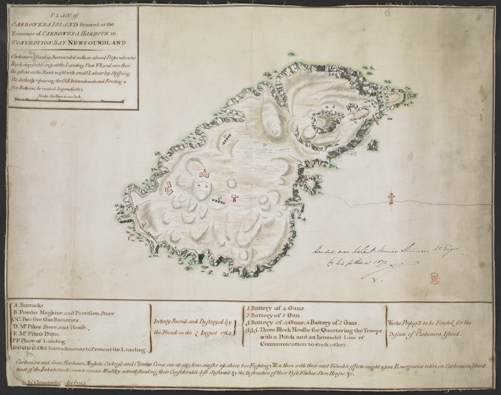
Relief shown by shading.
Shows Carbonear Island.
Shows title, short descriptive text and scale bar (Scale 200 Feet to an Inch") in a surround at upper left.
Shows signature and date at lower left.
Shows lettered and numbered key beneath the map. Letters denote fortifications "Intirely Burn'd and Destroyed by the French on the August 1762" while numbers show "Works Propos'd to be Erected for the Defence of Carbenera Island.
Fortifications designed by Des Barres (Kitson).
Copy at Add Ms 33,231.II.11. A roll. Manuscript annotation at centre right in black ink, "Handed over to Lieut. Monier Skinner R. Eng.r by his father in 1872" and initialled (by Monier Skinner?). Red stamp of British Museum at lower right. Pressmark stamped to verso and repeated in pencil.
- Notes (date):
-
9999


