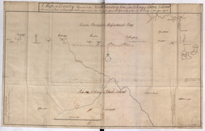
[Map showing the boundary line between the provinces of Massachusetts Bay and Connecticut by Woodward and Saffery in 1642 and as run in 1713]
![[Map showing the boundary line between the provinces of Massachusetts Bay and Connecticut by Woodward and Saffery in 1642 and as run in 1713]](https://bpldcassets.blob.core.windows.net/derivatives/images/commonwealth:hx11z5641/image_access_800.jpg)
Item Information
- Title:
- [Map showing the boundary line between the provinces of Massachusetts Bay and Connecticut by Woodward and Saffery in 1642 and as run in 1713]
- Description:
-
Shows "Connecticut River" and "Bissell's House". ||Outline map showing the Massachusetts/Connecticut borders as delineated in 1642 and 1713.
- Associated name:
- Woodward, Nathaniel, -1685
- Associated name:
- Saffery, Solomon
- Associated name:
- Bissell, Henry W.
- Date:
-
1713
- Format:
-
Maps/Atlases
- Location:
- British Library
- Collection (local):
-
British Library Collection
- Subjects:
-
Connecticut--Boundaries--Massachusetts--Maps, Manuscript--Early works to 1800
Connecticut--Maps, Manuscript--Early works to 1800
Massachusetts--Maps, Manuscript--Early works to 1800
- Places:
-
Connecticut
Massachusetts
- Extent:
- 1 map : manuscript pen and ink in black and red ; 55 x 27 cm
- Terms of Use:
-
No known copyright restrictions.
This work is licensed for use under a Creative Commons Attribution Non-Commercial Share Alike License (CC BY-NC-SA).

- Publisher:
-
[Place of production not identified] :
[producer not identified]
- Scale:
-
Scale not given
- Language:
-
English
- Catalog Record:
-
http://searcharchives.bl.uk/IAMS_VU2:IAMS032-002087248
- Notes:
-
Shows "The South Boundary Line of the Massachusets as run in 1713" and "The line as said to have been run by Woodward & Saffrey in 1642".
Copy at Add Ms 15,487.22. folds into a volume. Paper reinstated at lower left. Laid on linen. Red stamp of British Museum to verso.
- Notes (date):
-
9999

![This discription and [?] of the South Line of the Massachusetts Province which divides between the said Province and the Colony of Connecticut was made and Taken the Twenty Sixth day of October 1713 In Presence of Col. Samuel Partridge, Col. John Pynchon and [?] William Dudley Commissioners for the Massachusetts, and William Pithkin and William Whiting Esqrs for Connecticut wherein is discribed and Set down the Sain Line from Woodward and Saffery Station [?] to Connecticut River with the Several Towns farms and grants adjacent and Lying near the Same](https://bpldcassets.blob.core.windows.net/derivatives/images/commonwealth:hx11z566k/image_thumbnail_300.jpg)
![[A map of part of New York, comprehending the country between New York and Quebec, the river Connecticut, &c., to shew "the way from Albany to Canada ..... part by land and part by water;" drawn about 1720, on a scale of 31 miles to an inch]](https://bpldcassets.blob.core.windows.net/derivatives/images/commonwealth:6108vw070/image_thumbnail_300.jpg)
![[A map of part of New York, comprehending the country between New York and Quebec, the river Connecticut, &c., to shew "the way from Albany to Canada ..... part by land and part by water;" drawn about 1720, on a scale of 31 miles to an inch]](https://bpldcassets.blob.core.windows.net/derivatives/images/commonwealth:6108vw09j/image_thumbnail_300.jpg)