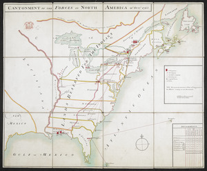
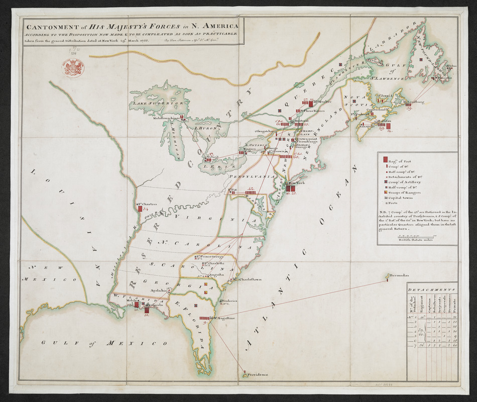
CANTONMENT of HIS MAJESTY'S FORCES in N. AMERICA ACCORDING TO THE DISPOSITION NOW MADE & TO BE COMPLETED AS SOON AS PRACTICABLE taken from the general Distribution dated at New York 29.th March 1766
This map is also available in American Revolutionary Geographies Online (ARGO), a collections portal especially built for material relating to the American Revolutionary War Era. Visit ARGO to learn more about this item and explore the historical geography of North America in the late eighteenth century.
Item Information
- Title:
- CANTONMENT of HIS MAJESTY'S FORCES in N. AMERICA ACCORDING TO THE DISPOSITION NOW MADE & TO BE COMPLETED AS SOON AS PRACTICABLE taken from the general Distribution dated at New York 29.th March 1766
- Cartographer:
- Paterson, Daniel, 1738-1825
- Name on Item:
-
By Dan. Paterson Ass.t Q.r M.r Gen.l.
- Date:
-
[1766]
- Format:
-
Maps/Atlases
- Location:
- British Library
- Collection (local):
-
British Library Collection
- Subjects:
-
Military planning--United States--Maps, Manuscript--Early works to 1800
United States--Maps, Manuscript--Early works to 1800
- Places:
-
- Extent:
- 1 map : dissected in 12 pieces and laid on linen, manuscript pen and ink with watercolour ; 51 x 62 cm
- Terms of Use:
-
No known copyright restrictions.
This work is licensed for use under a Creative Commons Attribution Non-Commercial Share Alike License (CC BY-NC-SA).

- Publisher:
-
[Place of production not identified] :
By Dan. Paterson Ass.t Q.r M.r Gen.l,
- Scale:
-
Scale approximately 1:6,500,000
- Language:
-
English
- Catalog Record:
-
http://searcharchives.bl.uk/IAMS_VU2:IAMS032-002109046
- Notes:
-
Shows British military forces in North America. Key at centre right identifies regiments, companies, half companies, detachments, companies of artillery and troops of rangers.
Shows and names forts.
Shows borders and boundaries with outline colour.
Shows "RESERVED COUNTRY" immediately to the east of the Mississippi River.
Shows scale bar at centre right in "British Statute Miles".
Shows table of detachments at lower right detailing the number of each rank.
Compare an additional, earlier map of the cantonment (see Add MS 11,287.).
Compare "Cantonment of the forces in North America 11th. Octr. 1765" held by the Library of Congress (Call Number G3301.R2 1765 .C3 Vault).
Compare "Cantonment of the forces in North America 11th October, 1765" held by the John Hopkins Library (E195 .C23 c. 1).
Copy at Add Ms 11,288. is dissected into 12 pieces and laid on (new) linen. Shows oval stamp of the British Museum in red at upper left and "37 21 234 9" added in pencil. Label to verso shows "Cantonment in America 1766" with additional "Purchased 10 Dec 1837" and giving the pressmark "MS.ADD.11,288". Additional label to verso repeats pressmark.
- Notes (date):
-
This date is inferred.