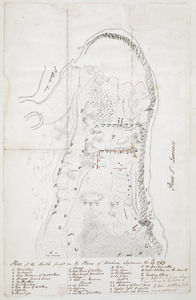
[Map of Quebec and environs showing the position of the English and French troops]
![[Map of Quebec and environs showing the position of the English and French troops]](https://bpldcassets.blob.core.windows.net/derivatives/images/commonwealth:hx11xz61s/image_access_800.jpg)
This map is also available in American Revolutionary Geographies Online (ARGO), a collections portal especially built for material relating to the American Revolutionary War Era. Visit ARGO to learn more about this item and explore the historical geography of North America in the late eighteenth century.
Item Information
- Title:
- [Map of Quebec and environs showing the position of the English and French troops]
- Former owner:
- Haldimand, Frederick, Sir, 1718-1791
- Date:
-
[1759]
- Format:
-
Maps/Atlases
- Location:
- British Library
- Collection (local):
-
British Library Collection
- Subjects:
-
Plains of Abraham, Battle of the, Québec, 1759--Maps, Manuscript--Early works to 1800
Fortification--Québec (Province)--Québec--Maps, Manuscript--Early works to 1800
Military art and science--Québec (Province)--Québec--Maps, Manuscript--Early works to 1800
Québec (Québec)--Maps, Manuscript--Early works to 1800
- Places:
-
CanadaQuébec
- Extent:
- 1 map : manuscript pen and ink with watercolour ; 37 x 46 cm
- Terms of Use:
-
No known copyright restrictions.
This work is licensed for use under a Creative Commons Attribution Non-Commercial Share Alike License (CC BY-NC-SA).

- Publisher:
-
[Quebec?] :
[producer not identified]
- Scale:
-
Scale approximately 1:3,600
- Language:
-
English
- Catalog Record:
-
http://searcharchives.bl.uk/IAMS_VU2:IAMS040-002034118
- Notes:
-
Date of production suggested as 1759, not 1760 as in previous British Library cataloguing. Map shows position of French and English troops during the Battle of the Plains of Abraham in 1759 (and not the Battle of Sainte Foy in 1760). Also shows "Landing Place" at the (unnamed on the map) Anse-au-Foulon.
Relief is shown by shading.
Names "Riv: S.t Laurentz".
Shows "Gen: Hospital".
Shows "Batteries against the Town" across the Saint Lawrence River from Quebec.
Text in French describes the colour used on the map, "Le Rouge est L'armee Angloise" and "le bleue est L'armee Francoise".
Previously catalogued by the British Library with Ms 21,686.81., but maps appear to be by different hands and spelling of the Saint Lawrence River differs.
Copy at Add Ms 21,686.68-69. Bound in a volume. Manuscript addition of "68" in pencil to verso and "69" to recto. Red stamp of British Museum to verso. Laid on archival tissue. Evidence of old folds. Paper watermark shows a coat of arms.
- Notes (date):
-
9999
This date is inferred.

![[Map of the environs of Quebec showing the position of the English and French troops]](https://bpldcassets.blob.core.windows.net/derivatives/images/commonwealth:hx11xz690/image_thumbnail_300.jpg)