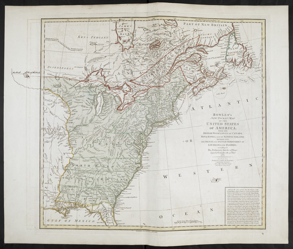
BOWLES'S NEW POCKET MAP OF THE UNITED STATES OF AMERICA : WITH THE BRITISH POSSESSIONS OF CANADA, NOVA SCOTIA, AND OF NEWFOUNDLAND: DIVIDED INTO THE FRENCH AND SPANISH TERRITORIES OF LOUISIANA AND FLORIDA, according to The Preliminary Articles of Peace, Signed at Versailles the 20.th Jan.y 1783
This map is also available in American Revolutionary Geographies Online (ARGO), a collections portal especially built for material relating to the American Revolutionary War Era. Visit ARGO to learn more about this item and explore the historical geography of North America in the late eighteenth century.
Item Information
- Title:
- BOWLES'S NEW POCKET MAP OF THE UNITED STATES OF AMERICA : WITH THE BRITISH POSSESSIONS OF CANADA, NOVA SCOTIA, AND OF NEWFOUNDLAND: DIVIDED INTO THE FRENCH AND SPANISH TERRITORIES OF LOUISIANA AND FLORIDA, according to The Preliminary Articles of Peace, Signed at Versailles the 20.th Jan.y 1783
- Publisher:
- Bowles, Carington, 1724-1793
- Name on Item:
-
LONDON Printed for & Sold by the Proprietor CARINGTON BOWLES, At his Map & Print Warehouse, No. 69 S.t Pauls Church Yard.
- Date:
-
1783
- Format:
-
Maps/Atlases
- Location:
- British Library
- Collection (local):
-
British Library Collection
- Subjects:
-
United States--Maps--Early works to 1800
North America--Maps--Early works to 1800
- Places:
-
North America (area)
- Extent:
- 1 map : copperplate engraving, hand colour ; 50 x 46 cm
- Terms of Use:
-
No known copyright restrictions.
This work is licensed for use under a Creative Commons Attribution Non-Commercial Share Alike License (CC BY-NC-SA).

- Publisher:
-
LONDON: :
Printed for & Sold by the Proprietor CARINGTON BOWLES, At his Map & Print Warehouse, No. 69 S.t Pauls Church Yard,
- Scale:
-
Scale approximately 1:6,336,000
- Language:
-
English
- Catalog Record:
-
http://searcharchives.bl.uk/IAMS_VU2:IAMS032-002087309
- Notes:
-
Relief shown pictorially.
State 1 of the map identified by its imprint - Baynton-Williams.
Shows imprint (date) in lower margin.
shows title at centre right.
Inset at lower right with Article III of the Treaty of Versailles.
Shows scale bar at lower centre in British Statute Miles.
Copy at Add Ms 15,535.7. Small red stamp of British Museum to verso. Manuscript addition in ink to map extends the Mississippi River westwards and adds the "Lake of the Woods".
- Notes (date):
-
9999


