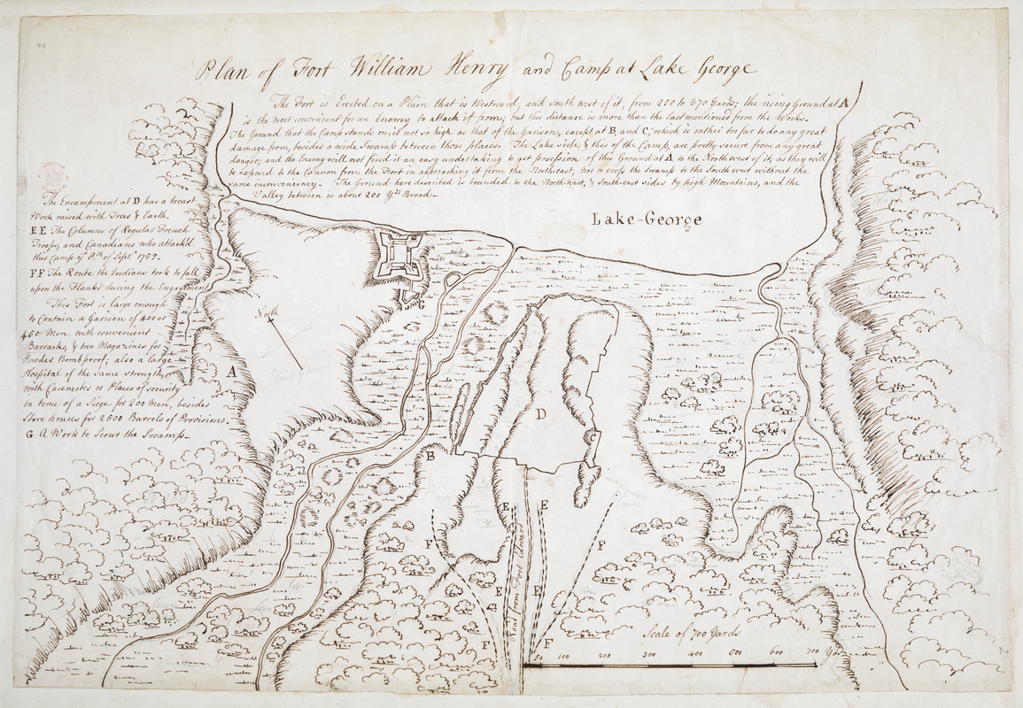
Plan of Fort William Henry and Camp at Lake George
This map is also available in American Revolutionary Geographies Online (ARGO), a collections portal especially built for material relating to the American Revolutionary War Era. Visit ARGO to learn more about this item and explore the historical geography of North America in the late eighteenth century.
Item Information
- Title:
- Plan of Fort William Henry and Camp at Lake George
- Associated name:
- Eyre, William, active 1755
- Date:
-
[ca. 1755]
- Format:
-
Maps/Atlases
- Location:
- British Library
- Collection (local):
-
British Library Collection
- Subjects:
-
Fortification--New York (State)--Fort William Henry--Maps, Manuscript--Early works to 1800
Military art and science--New York (State)--Fort William Henry--Maps, Manuscript--Early works to 1800
Fort William Henry (N.Y.)--Maps, Manuscript--Early works to 1800
- Places:
-
Warren (county)Fort William Henry (area)
- Extent:
- 1 map : manuscript pen and ink, over pencil ; 31 x 46 cm
- Terms of Use:
-
No known copyright restrictions.
This work is licensed for use under a Creative Commons Attribution Non-Commercial Share Alike License (CC BY-NC-SA).

- Publisher:
-
[Place of production not identified] :
[producer not identified]
- Scale:
-
Scale approximately 1:4,800
- Language:
-
English
- Catalog Record:
-
http://searcharchives.bl.uk/IAMS_VU2:IAMS032-002087309
- Notes:
-
Consider Thomas Eyre as cartographer with a date of production of about 1755 from comparison with Maps K.Top.121.108.2., Maps K.Top.121.108.3. and Maps K.Top.121.109.
Compare also the map by William Eyre and drawn by Joseph Heath held by the Library of Congress (Call Number: Faden 22 Vault and full classification number: G3804.L22:2F6S26 1755 .H4 Faden 22).
Relief shown by shading.
Shows scale bar at lower right, "Scale of 700 Yards".
Shows descriptive text at centre left and upper centre.
Copy at Add Ms 15,535.2. Small red stamp of British Museum at upper left. Pasted in an album, verso not visible.
- Notes (date):
-
9999

![[Plan Du fort Georges appelé par les Anglois William-Henri prie par les francois en 1757 le 9 Aout]](https://bpldcassets.blob.core.windows.net/derivatives/images/commonwealth:hx11z1913/image_thumbnail_300.jpg)
![[A map of Lake George from Fort William Henry to Ticonderoga]](https://bpldcassets.blob.core.windows.net/derivatives/images/commonwealth:hx11z3380/image_thumbnail_300.jpg)