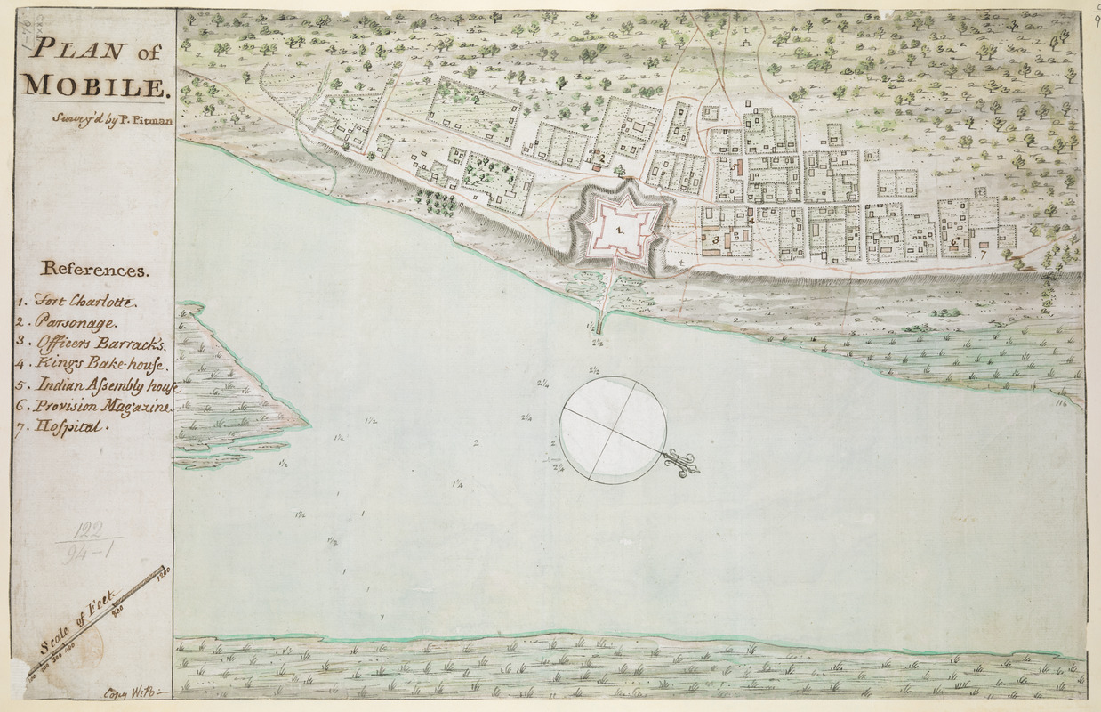
PLAN of MOBILE
This map is also available in American Revolutionary Geographies Online (ARGO), a collections portal especially built for material relating to the American Revolutionary War Era. Visit ARGO to learn more about this item and explore the historical geography of North America in the late eighteenth century.
Item Information
- Title:
- PLAN of MOBILE
- Surveyor:
- Pittman, Philip, active 1760-1770
- Former owner:
- George, III, King of Great Britain, 1738-1820
- Donor:
- George, IV, King of Great Britain, 1762-1830
- Cartographer:
- Brasier, William
- Name on Item:
-
Survey'd by P.Pittman.
- Date:
-
1763
- Format:
-
Maps/Atlases
Manuscripts
- Location:
- British Library
- Collection (local):
-
British Library Collection
- Subjects:
-
Mobile (Ala.)--Maps, Manuscript--Early works to 1800
Fort Charlotte (Mobile, Ala.)--Maps, Manuscript--Early works to 1800
- Places:
-
AlabamaMobile
- Extent:
- 1 map : manuscript pen and ink with watercolour ; 29 x 44 cm
- Terms of Use:
-
No known copyright restrictions.
This work is licensed for use under a Creative Commons Attribution Non-Commercial Share Alike License (CC BY-NC-SA).

- Scale:
-
Scale approximately 1:4,800
- Language:
-
English
- Catalog Record:
-
http://explore.bl.uk/BLVU1:LSCOP-ALL:BLL01004987561
- Notes:
-
Relief shown pictorially.
Shows a "Scale of Feet" at lower left.
North is oriented to the right of the map oriented by a compass rose.
Shows title at upper left with a numbered key (1-7) identifying buildings of note, including "Fort Charlotte" (known as Fort Conde under French rule and Fort Carlotta under Spanish rule).
Compare "Plan of Mobile. Surveyed by Ph. Pittman. Copy by W. Brasier. MS. 400 feet to 1 inch" held by The National Archives, Kew (CO 700/FLORIDA25).
Titled "A drawn Plan of Mobile, surveyed by P. Pitman; copied by W. Brasier" in the Catalogue of Maps, Prints, Drawings, etc., forming the geographical and topographical collection attached to the Library of his late Majesty King George the third, etc., London, 1829.
Titled 'A colored "Plan of Mobile, surveyed by P. Pitman;" shewing Fort Charlotte; copied by W. Brasier, on a scale of 400 feet to an inch: 1 f. 6 in. x 11 in.' in the Catalogue of the manuscript maps, charts, and plans, and of the topographical drawings in the British Museum.


