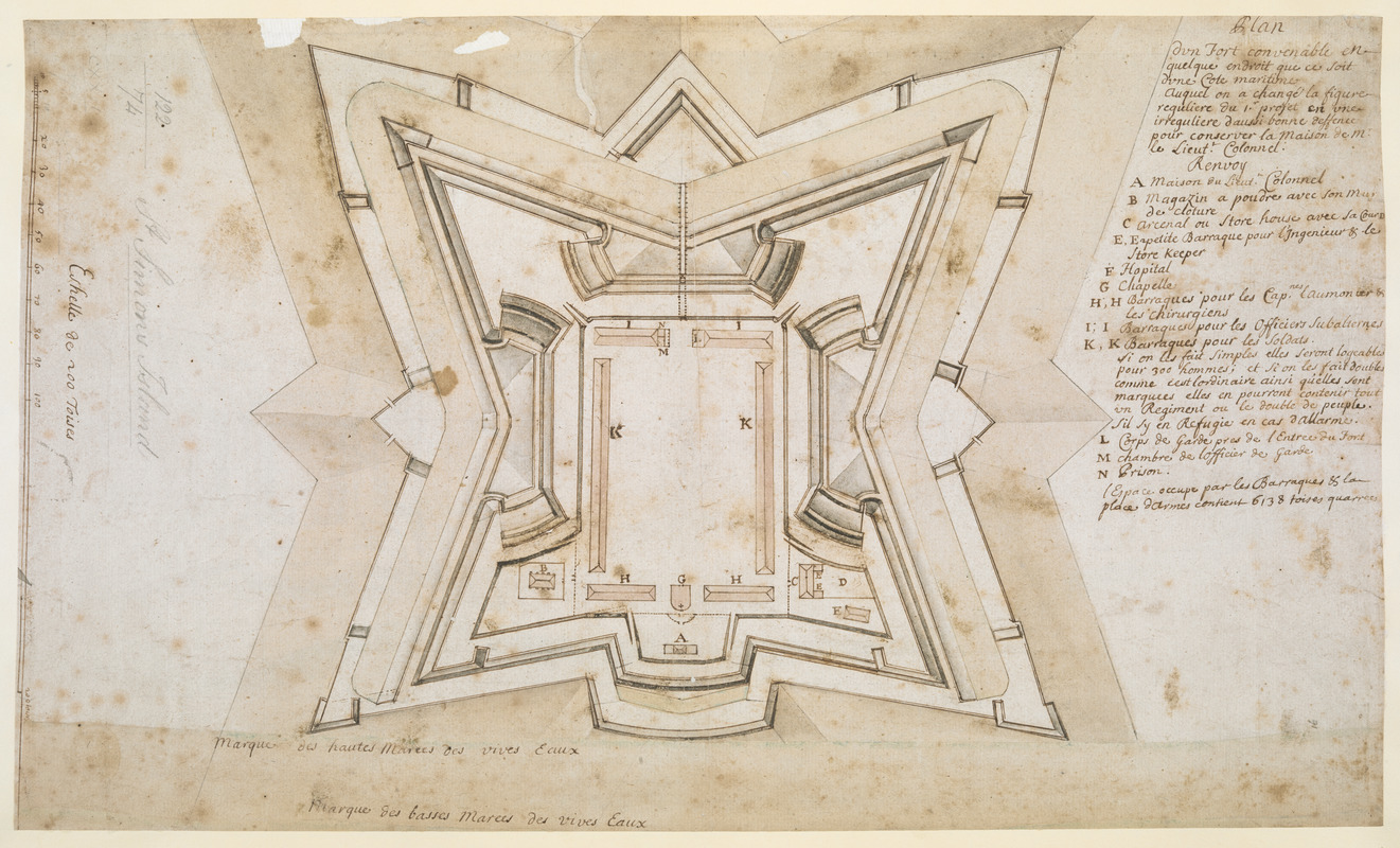
Plan dun Fort convenable en quelque endroit ce que soit dune Cote maritime Auquel on a changé la figure reguliere du 1.r Projet en une irreguliere daussi bonne deffence pour conserver la Maison de M.r le Liuet.t Colonnel
This map is also available in American Revolutionary Geographies Online (ARGO), a collections portal especially built for material relating to the American Revolutionary War Era. Visit ARGO to learn more about this item and explore the historical geography of North America in the late eighteenth century.
Item Information
- Title:
- Plan dun Fort convenable en quelque endroit ce que soit dune Cote maritime Auquel on a changé la figure reguliere du 1.r Projet en une irreguliere daussi bonne deffence pour conserver la Maison de M.r le Liuet.t Colonnel
- Cartographer:
- Thomas, John, the Elder
- Former owner:
- George, III, King of Great Britain, 1738-1820
- Donor:
- George, IV, King of Great Britain, 1762-1830
- Date:
-
1738
- Format:
-
Maps/Atlases
Manuscripts
- Location:
- British Library
- Collection (local):
-
British Library Collection
- Subjects:
-
Military art and science--Georgia--Saint Simons Island--Maps, Manuscript--Early works to 1800
Fortification--Georgia--Saint Simons Island--Maps, Manuscript--Early works to 1800
Saint Simons Island (Ga.)--Maps, Manuscript--Early works to 1800
- Places:
-
Glynn (county)Saint Simons Island (island)
- Extent:
- 1 map : manuscript pen and ink with watercolour over pencil ; 28 x 47 cm
- Terms of Use:
-
No known copyright restrictions.
This work is licensed for use under a Creative Commons Attribution Non-Commercial Share Alike License (CC BY-NC-SA).

- Scale:
-
Scale approximately 1:1,750
- Language:
-
French
- Catalog Record:
-
http://explore.bl.uk/BLVU1:LSCOP-ALL:BLL01004987602
- Notes:
-
Production details from a manuscript note in the British Museum catalogue (Maps C.21 bb.3) referencing a letter from Mrs Margaret Davis Cate, 29 July 1955.
Cumming (third edition) does not attribute the map to John Thomas and dates the map about 1760, but also suggests this may be incorrect.
With an "Eschelle de 200 Toises" at the left of the map.
Title at upper right.
With a lettered key (A-N) beneath the title identifying locations of note within the fort.
Compare Maps K.Top.122.72. including a paper overlay, also with a note regarding the conservation of the Lieutenant Colonel's quarters within the plan.
Titled "Plan dessiné d'un Fort dans l'Isle de St. Simon" in the Catalogue of Maps, Prints, Drawings, etc., forming the geographical and topographical collection attached to the Library of his late Majesty King George the third, etc., London, 1829.
Titled "Plan d'un fort convenable en quelque endroit que ce soit d'une cote maritime" in St. Simon's Island; drawn a scale of 32 toises to an inch: 2 f. x 11 in. in the Catalogue of the manuscript maps, charts, and plans, and of the topographical drawings in the British Museum.
Proposed fortifications on the southern tip of Saint Simons Island, Georgia.


![[Map of the proposed fort and adjacent redoubt on Saint Simons Island]](https://bpldcassets.blob.core.windows.net/derivatives/images/commonwealth:hx11z468x/image_thumbnail_300.jpg)
