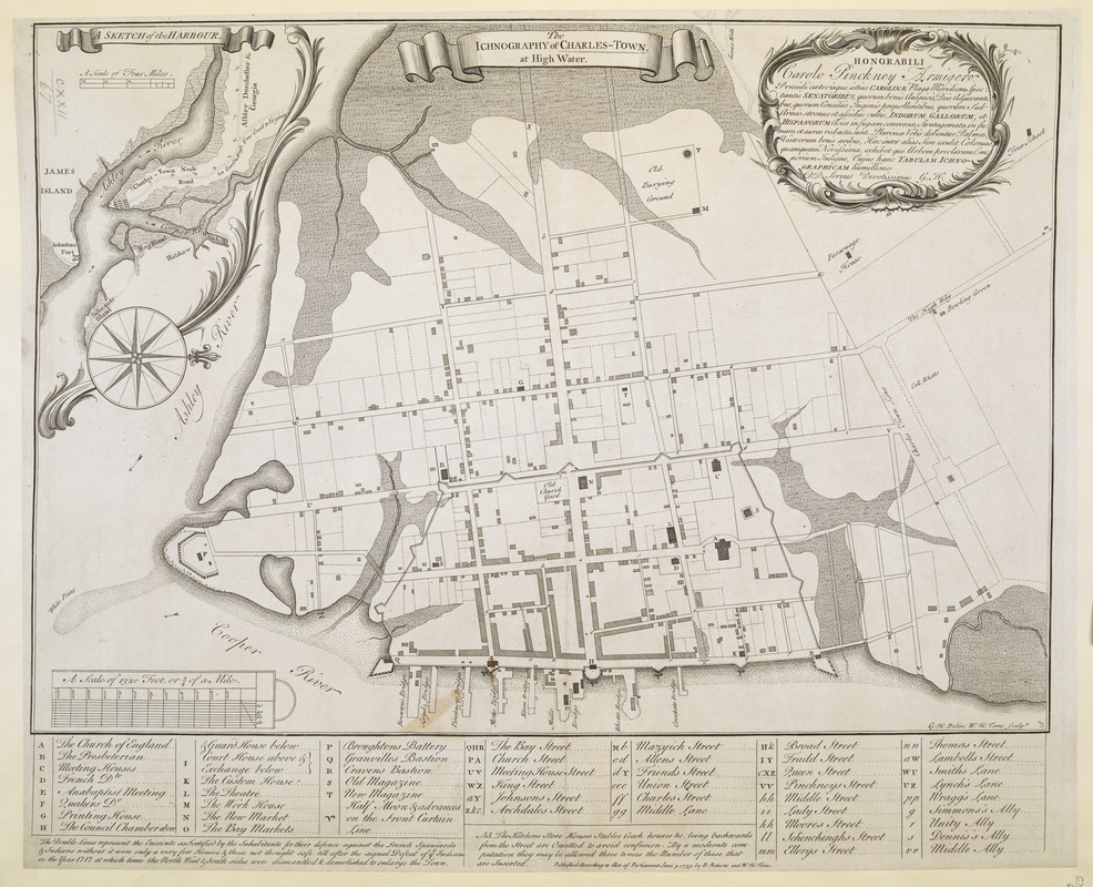
The ICHNOGRAPHY of CHARLES-TOWN, at High Water
Item Information
- Title:
- The ICHNOGRAPHY of CHARLES-TOWN, at High Water
- Title (alt.):
-
Charleston
- Cartographer:
- Hunter, George, -1755
- Former owner:
- George, III, King of Great Britain, 1738-1820
- Donor:
- George, IV, King of Great Britain, 1762-1830
- Contributor:
- Hunter, George, -1755
- Dedicatee:
- Pinckney, Charles, 1699-1758
- Printmaker:
- Toms, W. H. (William Henry), approximately 1700-approximately 1750
- Publisher:
- Roberts, Bishop, -1739
- Name on Item:
-
G:H: Delin: W:H: Toms Sculp.t.
- Date:
-
1739
- Format:
-
Maps/Atlases
- Location:
- British Library
- Collection (local):
-
British Library Collection
- Subjects:
-
Harbors--South Carolina--Charleston--Maps--Early works to 1800
Charleston (S.C.)--Maps--Early works to 1800
- Places:
-
Charleston (county)Charleston
- Extent:
- 1 map ; copperplate engraving ; 44 x 53 cm
- Terms of Use:
-
No known copyright restrictions.
This work is licensed for use under a Creative Commons Attribution Non-Commercial Share Alike License (CC BY-NC-SA).

- Publisher:
-
[London] :
Published According to Act of Parliament June 9. 1739. by B: Roberts and W: H: Toms
- Scale:
-
Scale approximately 1:4,000
- Language:
-
English
Latin
- Catalog Record:
-
http://explore.bl.uk/BLVU1:LSCOP-ALL:BLL01004818452
- Notes:
-
Relief shown by shading.
With "A Scale of 1320 Feet, or 1/4 of a Mile" at lower left in diagrammatic form.
Title in banner at upper centre.
Dedication at upper right in decorative cartouche to "Carolo Pinckney Armigero" [Charles Pinckney] signed "D.D. Dervus Devotissimus G. H.".
Signed "G:H: Delin: W:H: Toms Sculp.t" at lower right.
Imprint at lower centre.
With a lettered key beneath the map identifying buildings and locations of note.
Inset at upper left with "A SKETCH of the HARBOUR" showing Charleston within its wider environs (scale approximately 1:31,680).
Cumming notes copies of the map held by the John Carter Brown Library (Call number Cabinet Ce739 1) and by the Henry P. Kendall Collection in the South Caroliniana Library at the University of South Carolina.
The digital copy of the John Carter Brown Library example of the map (available online) suggests George Hunter, Surveyor General of the Carolinas, as cartographer of this map in an accompanying note (previous attributions for this map have included Hubert François Gravelot).
Titled "The Ichnography of Charles-Town in South Carolina, by G.H.; engraved by Toms, 1739" in the Catalogue of Maps, Prints, Drawings, etc., forming the geographical and topographical collection attached to the Library of his late Majesty King George the third, etc., London, 1829.
Title and nomenclature in English. Dedication in Latin.